Geolokalisieren

Topografische Karte 尼公

Interaktive Karte

Klicken Sie auf die Karte, um die Höhe anzuzeigen.

Über diese Karte

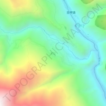
Name: Topografische Karte 尼公, Höhe, Relief.

Ort: 尼公, 稻城县, 甘孜藏族自治州, 四川省, 627700, 中国 (28.07501 100.23390 28.11501 100.27390)

Durchschnittliche Höhe: 2.505 m

Minimale Höhe: 1.998 m

Maximale Höhe: 3.456 m

Andere topografische Karten

Klicken Sie auf eine Karte, um ihre Topografie, ihre Höhe und ihr Relief anzuzeigen.

格辉

中国 > 四川省 > 稻城县

格辉, 稻城县, 甘孜藏族自治州, 四川省, 627700, 中国

Durchschnittliche Höhe: 3.476 m

吉呷镇

中国 > 四川省 > 稻城县

吉呷镇, 稻城县, 甘孜藏族自治州, 四川省, 627700, 中国

Durchschnittliche Höhe: 2.779 m

金珠镇

中国 > 四川省 > 稻城县

金珠镇, 稻城县, 甘孜藏族自治州, 四川省, 627700, 中国

Durchschnittliche Höhe: 3.859 m

桑堆镇

中国 > 四川省 > 稻城县

桑堆镇, 稻城县, 甘孜藏族自治州, 四川省, 中国

Durchschnittliche Höhe: 4.244 m

高海拔宇宙线观测站

中国 > 四川省 > 稻城县

高海拔宇宙线观测站, 张掖 - 孟连, 稻城县, 甘孜藏族自治州, 四川省, 中国

Durchschnittliche Höhe: 4.421 m

卜牙

中国 > 四川省 > 稻城县

卜牙, 稻城县, 甘孜藏族自治州, 四川省, 中国

Durchschnittliche Höhe: 4.123 m

稻城县

中国 > 四川省 > 稻城县

稻城县, 甘孜藏族自治州, 四川省, 627700, 中国

Durchschnittliche Höhe: 4.330 m

香格里拉镇

中国 > 四川省 > 稻城县

香格里拉镇, 稻城县, 甘孜藏族自治州, 四川省, 627700, 中国

Durchschnittliche Höhe: 3.494 m

稻城亚丁

中国 > 四川省 > 稻城县

稻城亚丁, 稻城县, 甘孜藏族自治州, 四川省, 627700, 中国

Durchschnittliche Höhe: 4.038 m

亚丁

中国 > 四川省 > 稻城县

亚丁, 稻城县, 甘孜藏族自治州, 四川省, 中国

Durchschnittliche Höhe: 4.187 m