
Topografische Karte Fabares
Interaktive Karte
Klicken Sie auf die Karte, um die Höhe anzuzeigen.
Über diese Karte
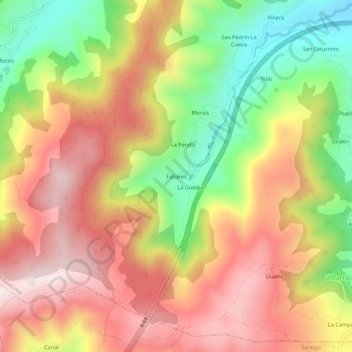
Name: Topografische Karte Fabares, Höhe, Relief.
Ort: Fabares, Villaviciosa, Asturias, 33518, España (43.42005 -5.55988 43.46005 -5.51988)
Durchschnittliche Höhe: 380 m
Minimale Höhe: 74 m
Maximale Höhe: 638 m
Andere topografische Karten
Klicken Sie auf eine Karte, um ihre Topografie, ihre Höhe und ihr Relief anzuzeigen.
Quintes
España > Asturias > Villaviciosa > Cimadevilla
Quintes, Cimadevilla, Villaviciosa, Asturias, 33294, España
Durchschnittliche Höhe: 107 m
Peón
España > Asturias > Villaviciosa
Peón, Villaviciosa, Asturias, España
Durchschnittliche Höhe: 224 m
La Rivera
España > Asturias > Villaviciosa
La Rivera, Villaviciosa, Asturias, España
Durchschnittliche Höhe: 213 m
Punta de la Mesnada
España > Asturias > Villaviciosa
Punta de la Mesnada, Villaviciosa, Asturias, 33315, España
Durchschnittliche Höhe: 44 m
El Monasterio
España > Asturias > Villaviciosa
El Monasterio, Villaviciosa, Asturias, 33314, España
Durchschnittliche Höhe: 77 m
La Viesca
España > Asturias > Villaviciosa
La Viesca, Villaviciosa, Asturias, España
Durchschnittliche Höhe: 202 m
Casquita
España > Asturias > Villaviciosa > Casquita
Casquita, Villaviciosa, Asturias, 33300, España
Durchschnittliche Höhe: 80 m
Barzana
España > Asturias > Villaviciosa > Barzana
Barzana, Villaviciosa, Asturias, 33317, España
Durchschnittliche Höhe: 94 m
Río España
España > Asturias > Villaviciosa > Santa Ana
Río España, Santa Ana, Villaviciosa, Asturias, España
Durchschnittliche Höhe: 78 m
Río de la Ría
España > Asturias > Villaviciosa
Río de la Ría, Villaviciosa, Asturias, 33300, España
Durchschnittliche Höhe: 60 m
Lavares
España > Asturias > Villaviciosa
Lavares, Villaviciosa, Asturias, 33300, España
Durchschnittliche Höhe: 121 m