
Spenden
Rüste dich für dein nächstes Abenteuer:
Als Amazon-Partner verdient diese Website an qualifizierten Käufen, ohne zusätzliche Kosten für Sie.
Topografische Karte Stanstead St Margarets
Klicken Sie auf die Karte, um die Höhe anzuzeigen.
Spenden
Rüste dich für dein nächstes Abenteuer:
Als Amazon-Partner verdient diese Website an qualifizierten Käufen, ohne zusätzliche Kosten für Sie.
Über diese Karte
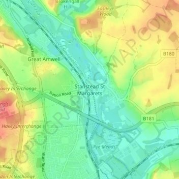
Name: Topografische Karte Stanstead St Margarets, Höhe, Relief.
Durchschnittliche Höhe: 48 m
Minimale Höhe: 21 m
Maximale Höhe: 92 m
Spenden
Rüste dich für dein nächstes Abenteuer:
Als Amazon-Partner verdient diese Website an qualifizierten Käufen, ohne zusätzliche Kosten für Sie.
Andere topografische Karten
Klicken Sie auf eine Karte, um ihre Topografie, ihre Höhe und ihr Relief anzuzeigen.
Astonbury Wood
United Kingdom > England > Hertfordshire > East Hertfordshire > Aston
Durchschnittliche Höhe: 83 m
Bishop's Stortford
United Kingdom > England > Hertfordshire > East Hertfordshire
Stortford, along with the rest of Britain, has a temperate maritime climate, with cool summers and mild winters. The nearest weather station for which averages and extremes are available is Stansted Airport, about 2+1⁄2 miles (4 kilometres) due east of Stortford's town centre. Located at an elevation of over…
Durchschnittliche Höhe: 83 m
Spenden
Rüste dich für dein nächstes Abenteuer:
Als Amazon-Partner verdient diese Website an qualifizierten Käufen, ohne zusätzliche Kosten für Sie.
Aston
United Kingdom > England > Hertfordshire > East Hertfordshire > Aston
Durchschnittliche Höhe: 99 m
Spenden
Rüste dich für dein nächstes Abenteuer:
Als Amazon-Partner verdient diese Website an qualifizierten Käufen, ohne zusätzliche Kosten für Sie.
King's Meads
United Kingdom > England > Hertfordshire > East Hertfordshire > Ware
Durchschnittliche Höhe: 53 m
Furneux Pelham
United Kingdom > England > Hertfordshire > East Hertfordshire > Furneux Pelham
Durchschnittliche Höhe: 113 m
Thundridge
United Kingdom > England > Hertfordshire > East Hertfordshire > High Cross
Durchschnittliche Höhe: 78 m
Spenden
Rüste dich für dein nächstes Abenteuer:
Als Amazon-Partner verdient diese Website an qualifizierten Käufen, ohne zusätzliche Kosten für Sie.
Little Hadham
United Kingdom > England > Hertfordshire > East Hertfordshire
Durchschnittliche Höhe: 91 m
Stocking Pelham
United Kingdom > England > Hertfordshire > East Hertfordshire > Stocking Pelham
Durchschnittliche Höhe: 114 m
Little Berkhamsted
United Kingdom > England > Hertfordshire > East Hertfordshire
Durchschnittliche Höhe: 88 m
Datchworth
United Kingdom > England > Hertfordshire > East Hertfordshire > Datchworth
Durchschnittliche Höhe: 102 m
Spenden
Rüste dich für dein nächstes Abenteuer:
Als Amazon-Partner verdient diese Website an qualifizierten Käufen, ohne zusätzliche Kosten für Sie.
River Stort
United Kingdom > England > Hertfordshire > East Hertfordshire
Durchschnittliche Höhe: 90 m
Thorley
United Kingdom > England > Hertfordshire > East Hertfordshire > Thorley
Durchschnittliche Höhe: 82 m
Sawbridgeworth
United Kingdom > England > Hertfordshire > East Hertfordshire > Sawbridgeworth
Durchschnittliche Höhe: 67 m
Spenden
Rüste dich für dein nächstes Abenteuer:
Als Amazon-Partner verdient diese Website an qualifizierten Käufen, ohne zusätzliche Kosten für Sie.
Much Hadham
United Kingdom > England > Hertfordshire > East Hertfordshire
Durchschnittliche Höhe: 80 m
Buntingford
United Kingdom > England > Hertfordshire > East Hertfordshire > Buntingford
Durchschnittliche Höhe: 110 m
Widford
United Kingdom > England > Hertfordshire > East Hertfordshire > Widford
Durchschnittliche Höhe: 73 m
Tewin
United Kingdom > England > Hertfordshire > East Hertfordshire > Tewin
Durchschnittliche Höhe: 91 m
Spenden
Rüste dich für dein nächstes Abenteuer:
Als Amazon-Partner verdient diese Website an qualifizierten Käufen, ohne zusätzliche Kosten für Sie.
Hertford Heath Nature Reserve
United Kingdom > England > Hertfordshire > East Hertfordshire > Hertford Heath
Durchschnittliche Höhe: 79 m
Hertingfordbury
United Kingdom > England > Hertfordshire > East Hertfordshire
Durchschnittliche Höhe: 68 m
Hertford Heath
United Kingdom > England > Hertfordshire > East Hertfordshire
Durchschnittliche Höhe: 74 m
Spenden
Rüste dich für dein nächstes Abenteuer:
Als Amazon-Partner verdient diese Website an qualifizierten Käufen, ohne zusätzliche Kosten für Sie.
Hertford Lock No 1
United Kingdom > England > Hertfordshire > East Hertfordshire > Hertford
Durchschnittliche Höhe: 53 m
Stocking Pelham
United Kingdom > England > Hertfordshire > East Hertfordshire
Durchschnittliche Höhe: 114 m
Braughing
United Kingdom > England > Hertfordshire > East Hertfordshire > Braughing
Durchschnittliche Höhe: 104 m
Spenden
Rüste dich für dein nächstes Abenteuer:
Als Amazon-Partner verdient diese Website an qualifizierten Käufen, ohne zusätzliche Kosten für Sie.
Sawbridgeworth
United Kingdom > England > Hertfordshire > East Hertfordshire > Sawbridgeworth
Durchschnittliche Höhe: 67 m
Buntingford
United Kingdom > England > Hertfordshire > East Hertfordshire > Buntingford
Durchschnittliche Höhe: 110 m