
Topografische Karte Monument
Interaktive Karte
Klicken Sie auf die Karte, um die Höhe anzuzeigen.
Über diese Karte
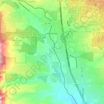
Name: Topografische Karte Monument, Höhe, Relief.
Ort: Monument, El Paso County, Colorado, United States (39.04220 -104.88472 39.11504 -104.79116)
Durchschnittliche Höhe: 2.160 m
Minimale Höhe: 2.035 m
Maximale Höhe: 2.409 m
Monument experiences a hemiboreal continental climate (Köppen Dfb) with warm, relatively rainy summers and cold, snowy winters. As with many areas of Colorado, Monument experiences a lot of sunshine with an average of 250 sunny days per year. The semi-arid climate keeps the dew point very low in Monument year-round and causes the air to feel quite dry. Monument is part of the Front Range urban corridor and lies on the southern slope of Monument Hill. The town is situated near the western terminus of the Palmer Divide, a low-grade ridge that extends Eastward from the Front Range and has a significant impact on Monument's climate. With the top of Monument Hill reaching 7,352 feet above sea level, Monument is one of the highest communities in the Front Range urban corridor. The combination of high elevation, uniquely situated geography, semi-arid climate, and freezing cold winter months causes the town of Monument to receive considerably more snow each year than its neighboring cities. Colorado Springs (20 miles to the South) receives an average of 33 inches of snow per year and Denver (53 miles to the North) receives an average of 56 inches of snow per year, whereas the town of Monument receives an average of 110 inches of snow per year.
Andere topografische Karten
Klicken Sie auf eine Karte, um ihre Topografie, ihre Höhe und ihr Relief anzuzeigen.
Colorado Springs
United States > Colorado > El Paso County
Colorado Springs, El Paso County, Colorado, United States
Durchschnittliche Höhe: 2.252 m
Sleeping Giant
United States > Colorado > El Paso County > Colorado Springs
Sleeping Giant, Colorado Springs, El Paso County, Colorado, United States
Durchschnittliche Höhe: 1.971 m
Manitou Springs
United States > Colorado > El Paso County
Manitou Springs, El Paso County, Colorado, 80829, United States
Durchschnittliche Höhe: 2.144 m
Lake Moraine
United States > Colorado > El Paso County
Lake Moraine, El Paso County, Colorado, United States
Durchschnittliche Höhe: 3.163 m
Fort Carson
United States > Colorado > El Paso County > Fort Carson
Fort Carson, El Paso County, Colorado, United States
Durchschnittliche Höhe: 1.786 m
Colorado Springs
United States > Colorado > El Paso County
Colorado Springs, El Paso County, Colorado, 80903, United States
Durchschnittliche Höhe: 2.229 m
Buttes
United States > Colorado > El Paso County
Buttes, El Paso County, Colorado, United States
Durchschnittliche Höhe: 1.639 m
Big Horn Dam
United States > Colorado > El Paso County
Big Horn Dam, El Paso County, Colorado, United States
Durchschnittliche Höhe: 3.697 m
Fountain
United States > Colorado > El Paso County > Fountain
Fountain, El Paso County, Colorado, United States
Durchschnittliche Höhe: 1.719 m
Pikes Peak
United States > Colorado > El Paso County
Pikes Peak, El Paso County, Colorado, United States
Durchschnittliche Höhe: 3.902 m