
Topografische Karte Zibreira
Interaktive Karte
Klicken Sie auf die Karte, um die Höhe anzuzeigen.
Über diese Karte
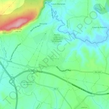
Name: Topografische Karte Zibreira, Höhe, Relief.
Ort: Zibreira, Torres Novas, Santarém, Portugal (39.46600 -8.63750 39.50560 -8.58637)
Durchschnittliche Höhe: 108 m
Minimale Höhe: 59 m
Maximale Höhe: 238 m
Andere topografische Karten
Klicken Sie auf eine Karte, um ihre Topografie, ihre Höhe und ihr Relief anzuzeigen.
Aire
Portugal > Santarém > Torres Novas
Aire, Torres Novas, Santarém, 2495-079, Portugal
Durchschnittliche Höhe: 553 m
Vargos
Portugal > Santarém > Torres Novas
Vargos, Olaia e Paço, Torres Novas, Santarém, 2350-177, Portugal
Durchschnittliche Höhe: 115 m
Rendufas da Mata
Portugal > Santarém > Torres Novas
Rendufas da Mata, Chancelaria, Torres Novas, Santarém, 2350-077, Portugal
Durchschnittliche Höhe: 106 m
Casais Martanes
Portugal > Santarém > Torres Novas
Casais Martanes, Pedrógão, Torres Novas, Santarém, 2350-852, Portugal
Durchschnittliche Höhe: 131 m