
Topografische Karte West Amherst
Interaktive Karte
Klicken Sie auf die Karte, um die Höhe anzuzeigen.
Über diese Karte
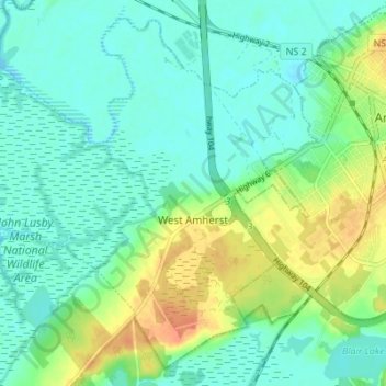
Name: Topografische Karte West Amherst, Höhe, Relief.
Durchschnittliche Höhe: 13 m
Minimale Höhe: -1 m
Maximale Höhe: 40 m
Andere topografische Karten
Klicken Sie auf eine Karte, um ihre Topografie, ihre Höhe und ihr Relief anzuzeigen.
Westchester
Canada > Nova Scotia > Municipality of the County of Cumberland
Westchester, Municipality of the County of Cumberland, Cumberland County, Nova Scotia, Canada
Durchschnittliche Höhe: 157 m
Mapleton
Canada > Nova Scotia > Municipality of the County of Cumberland
Mapleton, Municipality of the County of Cumberland, Cumberland County, Nova Scotia, B0M 1W0, Canada
Durchschnittliche Höhe: 102 m
Beckwith
Canada > Nova Scotia > Municipality of the County of Cumberland
Beckwith, Municipality of the County of Cumberland, Cumberland County, Nova Scotia, Canada
Durchschnittliche Höhe: 44 m
Northport
Canada > Nova Scotia > Municipality of the County of Cumberland
Northport, Municipality of the County of Cumberland, Cumberland County, Nova Scotia, B0L 1E0, Canada
Durchschnittliche Höhe: 12 m
Maccan
Canada > Nova Scotia > Municipality of the County of Cumberland
Maccan, Municipality of the County of Cumberland, Cumberland County, Nova Scotia, B0L 1B0, Canada
Durchschnittliche Höhe: 45 m
Parrsboro
Canada > Nova Scotia > Municipality of the County of Cumberland
Parrsboro, Municipality of the County of Cumberland, Cumberland County, Nova Scotia, B0M 1S0, Canada
Durchschnittliche Höhe: 25 m
Gulf Shore
Canada > Nova Scotia > Municipality of the County of Cumberland > Gulf Shore
Gulf Shore, Municipality of the County of Cumberland, Cumberland County, Nova Scotia, B0K 1L0, Canada
Durchschnittliche Höhe: 11 m