
Topografische Karte Elvillar
Interaktive Karte
Klicken Sie auf die Karte, um die Höhe anzuzeigen.
Über diese Karte
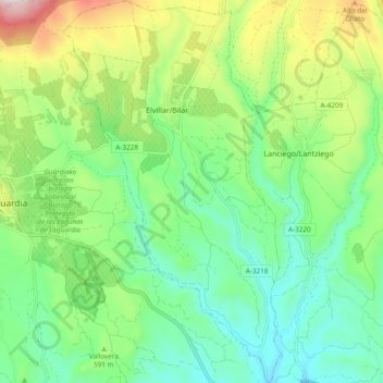
Name: Topografische Karte Elvillar, Höhe, Relief.
Ort: Elvillar, Rioja Alavesa, Álava, País Vasco, España (42.52054 -2.57098 42.59044 -2.51662)
Durchschnittliche Höhe: 559 m
Minimale Höhe: 388 m
Maximale Höhe: 927 m
Andere topografische Karten
Klicken Sie auf eine Karte, um ihre Topografie, ihre Höhe und ihr Relief anzuzeigen.
Laguardia
España > País Vasco > Rioja Alavesa
Laguardia, Rioja Alavesa, Álava, País Vasco, España
Durchschnittliche Höhe: 593 m
Barriobusto
España > País Vasco > Rioja Alavesa > Oyón
Barriobusto, Oyón, Rioja Alavesa, Álava, País Vasco, 01322, España
Durchschnittliche Höhe: 647 m
Lanciego
España > País Vasco > Rioja Alavesa
Lanciego, Rioja Alavesa, Álava, País Vasco, España
Durchschnittliche Höhe: 536 m
Labastida
España > País Vasco > Rioja Alavesa
Labastida, Rioja Alavesa, Álava, País Vasco, 01330, España
Durchschnittliche Höhe: 611 m
Oyón
España > País Vasco > Rioja Alavesa
Oyón, Rioja Alavesa, Álava, País Vasco, 01320, España
Durchschnittliche Höhe: 572 m