Topografische Karte Queensland
Interaktive Karte
Klicken Sie auf die Karte, um die Höhe anzuzeigen.
Über diese Karte
![Topografische Karte Queensland, Höhe, Relief](/pub/maps/relation/prmt/9q69cz/thumbnail.jpg)
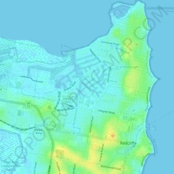
Name: Topografische Karte Queensland, Höhe, Relief.
Ort: Queensland, 4020, Australien (-27.23885 153.07263 -27.19051 153.11947)
Durchschnittliche Höhe: 5 m
Minimale Höhe: -4 m
Maximale Höhe: 28 m
Andere topografische Karten
Klicken Sie auf eine Karte, um ihre Topografie, ihre Höhe und ihr Relief anzuzeigen.
![Topografische Karte Melbourne, Höhe, Relief](/pub/maps/relation/xwkl/68shs8/icon.jpg)
Melbourne
Melbourne, City of Melbourne, Victoria, Australien
Durchschnittliche Höhe: 185 m
![Topografische Karte Sydney, Höhe, Relief](/pub/maps/relation/kl/p2x2cz/icon.jpg)
Sydney
Sydney, Council of the City of Sydney, Neusüdwales, Australien
Durchschnittliche Höhe: 53 m
![Topografische Karte Katoomba, Höhe, Relief](/pub/maps/relation/699m/wh5gtf/icon.jpg)
Katoomba
Australien > Neusüdwales > Sydney
Katoomba, Sydney, Blue Mountains City Council, Neusüdwales, 2780, Australien
Durchschnittliche Höhe: 912 m
![Topografische Karte 4160, Höhe, Relief](/pub/maps/relation/sj14/28gcnh/icon.jpg)
4160
4160, Wellington Point, Greater Brisbane, Redland City, Queensland, Australien
Durchschnittliche Höhe: 6 m
![Topografische Karte Canberra, Höhe, Relief](/pub/maps/node/swnh/119wfm2/icon.jpg)
Canberra
Canberra, District of Canberra Central, Australisches Hauptstadtterritorium, 2600, Australien
Durchschnittliche Höhe: 638 m
![Topografische Karte Sterling River, Höhe, Relief](/pub/maps/way/4tdn/s8pc43q/icon.jpg)
Sterling River
Australien > Tasmanien > Tullah
Sterling River, Tullah, West Coast, Tasmanien, Australien
Durchschnittliche Höhe: 246 m
![Topografische Karte Lobethal, Höhe, Relief](/pub/maps/relation/pb3q/wbq9b3/icon.jpg)
Lobethal
Lobethal, Adelaide Hills Council, Südaustralien, 5241, Australien
Durchschnittliche Höhe: 445 m
![Topografische Karte Australisches Hauptstadtterritorium, Höhe, Relief](/pub/maps/relation/fm18/wznq5k/icon.jpg)
Australisches Hauptstadtterritorium
Australisches Hauptstadtterritorium, Australien
Durchschnittliche Höhe: 971 m
![Topografische Karte Riverton, Höhe, Relief](/pub/maps/relation/8ldn/jbqmt6/icon.jpg)
Riverton
Riverton, Clare and Gilbert Valleys Council, Südaustralien, 5412, Australien
Durchschnittliche Höhe: 316 m
![Topografische Karte Lithgow City Council, Höhe, Relief](/pub/maps/relation/bg4s/949zb3/icon.jpg)
Lithgow City Council
Lithgow City Council, Neusüdwales, Australien
Durchschnittliche Höhe: 713 m
![Topografische Karte McDonald-Insel, Höhe, Relief](/pub/maps/way/lldn/6mm66z4/icon.jpg)
McDonald-Insel
McDonald-Insel, Heard und McDonaldinseln, Australien
Durchschnittliche Höhe: 26 m
![Topografische Karte Lucindale, Höhe, Relief](/pub/maps/relation/g35k/wqxgzs/icon.jpg)
Lucindale
Australien > Südaustralien > Naracoorte Lucindale Council
Lucindale, Naracoorte Lucindale Council, Südaustralien, 5272, Australien
Durchschnittliche Höhe: 34 m
![Topografische Karte Ingham, Höhe, Relief](/pub/maps/node/hndn/4tj5lgtp/icon.jpg)
Ingham
Ingham, Hinchinbrook Shire, Queensland, Australien
Durchschnittliche Höhe: 13 m
![Topografische Karte The Barossa Council, Höhe, Relief](/pub/maps/relation/mv51/54gq4s/icon.jpg)
The Barossa Council
The Barossa Council, Südaustralien, Australien
Durchschnittliche Höhe: 308 m
![Topografische Karte Saint Peter Island, Höhe, Relief](/pub/maps/way/wb18/7h67s18/icon.jpg)
Saint Peter Island
Saint Peter Island, Südaustralien, Australien
Durchschnittliche Höhe: 4 m
![Topografische Karte Bendigo, Höhe, Relief](/pub/maps/node/l8dn/wt33gnx/icon.jpg)
Bendigo
Bendigo, City of Greater Bendigo, Victoria, 3550, Australien
Durchschnittliche Höhe: 223 m
![Topografische Karte Gold Creek Reservoir, Höhe, Relief](/pub/maps/relation/s1s8/zdn95k/icon.jpg)
Gold Creek Reservoir
Australien > Queensland > Brisbane
Gold Creek Reservoir, Layhys Break, Upper Brookfield, Brisbane, Queensland, 4520, Australien
Durchschnittliche Höhe: 161 m
![Topografische Karte Dedin, Höhe, Relief](/pub/maps/relation/9vf3/bw24nh/icon.jpg)
Dedin
Dedin, Douglas Shire, Queensland, Australien
Durchschnittliche Höhe: 551 m
![Topografische Karte Tatiara District Council, Höhe, Relief](/pub/maps/relation/7rs8/d9t6gp/icon.jpg)
Tatiara District Council
Australien > Südaustralien > Tatiara District Council
Tatiara District Council, Südaustralien, Australien
Durchschnittliche Höhe: 71 m
![Topografische Karte Mungo National Park, Höhe, Relief](/pub/maps/relation/shb3/ckjsnx/icon.jpg)
Mungo National Park
Mungo National Park, Balranald Shire Council, Neusüdwales, Australien
Durchschnittliche Höhe: 81 m
![Topografische Karte Griers Creek, Höhe, Relief](/pub/maps/way/6ftf/7gr2t5t6/icon.jpg)
Griers Creek
Griers Creek, Tweed Shire Council, Neusüdwales, Australien
Durchschnittliche Höhe: 196 m
![Topografische Karte Yulara, Höhe, Relief](/pub/maps/node/k6b3/1f8wmrr/icon.jpg)
Yulara
Australien > Nordterritorium > Yulara
Yulara, Nordterritorium, Australien
Durchschnittliche Höhe: 507 m
![Topografische Karte Gold Coast, Höhe, Relief](/pub/maps/node/49m/d8nrhz4/icon.jpg)
Gold Coast
Australien > Queensland > Gold Coast
Gold Coast, Queensland, 4217, Australien
Durchschnittliche Höhe: 42 m
![Topografische Karte Brompton, Höhe, Relief](/pub/maps/relation/xgtf/wnq418/icon.jpg)
Brompton
Brompton, Charles Sturt, Südaustralien, 5007, Australien
Durchschnittliche Höhe: 24 m
![Topografische Karte Trentham, Höhe, Relief](/pub/maps/node/fzs/vpffb7rr/icon.jpg)
Trentham
Australien > Victoria > Trentham
Trentham, Shire of Hepburn, Grampians, Victoria, 3458, Australien
Durchschnittliche Höhe: 713 m
![Topografische Karte Laverton, Höhe, Relief](/pub/maps/node/ncrr/bzf6t5k/icon.jpg)
Laverton
Australien > Westaustralien > Laverton
Laverton, Westaustralien, 6440, Australien
Durchschnittliche Höhe: 461 m
![Topografische Karte Hyden, Höhe, Relief](/pub/maps/node/g9nx/95sjbgt/icon.jpg)
Hyden
Australien > Westaustralien > Hyden
Hyden, Westaustralien, 6359, Australien
Durchschnittliche Höhe: 312 m
![Topografische Karte Pambula, Höhe, Relief](/pub/maps/node/7l3l/7fc3sb3/icon.jpg)
Pambula
Australien > Neusüdwales > Pambula
Pambula, Bega Valley, Neusüdwales, 2549, Australien
Durchschnittliche Höhe: 47 m
![Topografische Karte Sydney CBD, Höhe, Relief](/pub/maps/relation/l351/lh1zmt/icon.jpg)
Sydney CBD
Australien > Neusüdwales > Sydney
Sydney CBD, Sydney, Neusüdwales, 2000, Australien
Durchschnittliche Höhe: 23 m
![Topografische Karte Glenorchy, Höhe, Relief](/pub/maps/node/f2dn/2wsdf5k/icon.jpg)
Glenorchy
Australien > Tasmanien > Glenorchy
Glenorchy, Tasmanien, 7010, Australien
Durchschnittliche Höhe: 122 m
![Topografische Karte Peeramon, Höhe, Relief](/pub/maps/node/lj51/mblz3mnh/icon.jpg)
Peeramon
Australien > Queensland > Peeramon
Peeramon, Queensland, Australien
Durchschnittliche Höhe: 745 m
![Topografische Karte Logandale, Höhe, Relief](/pub/maps/node/8lnh/fm1sqnh/icon.jpg)
Logandale
Australien > Queensland > Logandale
Logandale, Queensland, 4130, Australien
Durchschnittliche Höhe: 15 m
![Topografische Karte Mutitjulu, Höhe, Relief](/pub/maps/node/84s/hcx6xqdn/icon.jpg)
Mutitjulu
Australien > Nordterritorium > Mutitjulu
Mutitjulu, Nordterritorium, Australien
Durchschnittliche Höhe: 532 m
![Topografische Karte Middle Harbour, Höhe, Relief](/pub/maps/relation/53t6/j7795k/icon.jpg)
Middle Harbour
Australien > Neusüdwales > Sydney
Middle Harbour, Sydney, Neusüdwales, 2087, Australien
Durchschnittliche Höhe: 56 m
![Topografische Karte Williamstown, Höhe, Relief](/pub/maps/relation/l5zs/kwh99m/icon.jpg)
Williamstown
Williamstown, Barossa, Südaustralien, 5351, Australien
Durchschnittliche Höhe: 310 m
![Topografische Karte Alpine NP, Höhe, Relief](/pub/maps/relation/dsmt/d77nzs/icon.jpg)
Alpine NP
Alpine NP, Harrietville, Alpine Shire, Hume, Victoria, 3723, Australien
Durchschnittliche Höhe: 588 m
![Topografische Karte Dubbo, Höhe, Relief](/pub/maps/node/657/fjrwn9m/icon.jpg)
Dubbo
Australien > Neusüdwales > Dubbo
Dubbo, Western Plains, Neusüdwales, Australien
Durchschnittliche Höhe: 307 m
![Topografische Karte Great Sandy National Park, Höhe, Relief](/pub/maps/relation/p4cz/d6p3kl/icon.jpg)
Great Sandy National Park
Australien > Queensland > Hervey Bay
Great Sandy National Park, Hervey Bay, Queensland, Australien
Durchschnittliche Höhe: 32 m
![Topografische Karte Lara, Höhe, Relief](/pub/maps/relation/np3q/9xsmtf/icon.jpg)
Lara
Australien > Victoria > Geelong
Lara, Cohuna Court, Corio, Geelong, City of Greater Geelong, Barwon South West, Victoria, 3214, Australien
Durchschnittliche Höhe: 94 m
![Topografische Karte Hattah - Kulkyne NP, Höhe, Relief](/pub/maps/relation/mxm2/rkdqt6/icon.jpg)
Hattah - Kulkyne NP
Australien > Victoria > Colignan
Hattah - Kulkyne NP, Reed Road, Hattah, Colignan, Rural City of Mildura, Loddon Mallee, Victoria, Australien
Durchschnittliche Höhe: 51 m
![Topografische Karte Lake Mackay, Höhe, Relief](/pub/maps/node/6bmt/fmtxh1dn/icon.jpg)
Lake Mackay
Lake Mackay, Central Desert Region, Nordterritorium, Australien
Durchschnittliche Höhe: 430 m
![Topografische Karte Mount Tibberoowuccum, Höhe, Relief](/pub/maps/node/fddn/4mhz6tf/icon.jpg)
Mount Tibberoowuccum
Australien > Queensland > Caboolture
Mount Tibberoowuccum, Caboolture, Queensland, 4518, Australien
Durchschnittliche Höhe: 49 m
![Topografische Karte Mount Coonowrin, Höhe, Relief](/pub/maps/node/twtj/83mcvt6/icon.jpg)
Mount Coonowrin
Australien > Queensland > Caboolture
Mount Coonowrin, Caboolture, Queensland, Australien
Durchschnittliche Höhe: 78 m