
Topografische Karte Dhumakot
Interaktive Karte
Klicken Sie auf die Karte, um die Höhe anzuzeigen.
Über diese Karte
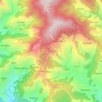
Name: Topografische Karte Dhumakot, Höhe, Relief.
Durchschnittliche Höhe: 1.605 m
Minimale Höhe: 1.133 m
Maximale Höhe: 2.054 m
Andere topografische Karten
Klicken Sie auf eine Karte, um ihre Topografie, ihre Höhe und ihr Relief anzuzeigen.
saraikhet
India > Uttarakhand > Dhoomakot
saraikhet, Dhoomakot, Pauri Garhwal District, Uttarakhand, India
Durchschnittliche Höhe: 1.861 m
Pateliya
India > Uttarakhand > Dhoomakot
Pateliya, Dhoomakot, Pauri Garhwal District, Uttarakhand, 246277, India
Durchschnittliche Höhe: 1.857 m
Palasi
India > Uttarakhand > Dhoomakot
Palasi, Dhoomakot, Pauri Garhwal District, Uttarakhand, 246279, India
Durchschnittliche Höhe: 1.254 m
Tandoli
India > Uttarakhand > Dhoomakot
Tandoli, Dhoomakot, Pauri Garhwal District, Uttarakhand, 246277, India
Durchschnittliche Höhe: 1.324 m
Chorgadh Malla
India > Uttarakhand > Dhoomakot > Patotidanda
Chorgadh Malla, Patotidanda, Dhoomakot, Pauri Garhwal District, Uttarakhand, 246277, India
Durchschnittliche Höhe: 1.377 m
Androli
India > Uttarakhand > Dhoomakot > Tandoli
Androli, Tandoli, Dhoomakot, Pauri Garhwal District, Uttarakhand, India
Durchschnittliche Höhe: 1.258 m