
Topografische Karte Αγιόκαμπος
Interaktive Karte
Klicken Sie auf die Karte, um die Höhe anzuzeigen.
Über diese Karte
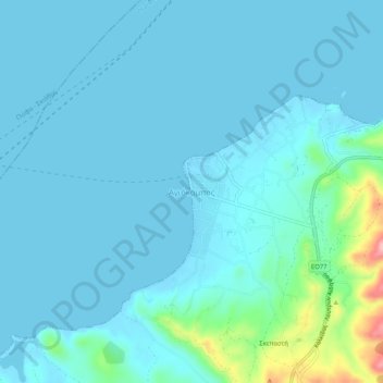
Name: Topografische Karte Αγιόκαμπος, Höhe, Relief.
Durchschnittliche Höhe: 16 m
Minimale Höhe: -2 m
Maximale Höhe: 142 m
Andere topografische Karten
Klicken Sie auf eine Karte, um ihre Topografie, ihre Höhe und ihr Relief anzuzeigen.
Chalcis
Grèce > Thessalie-Grèce centrale > Περιφερειακή Ενότητα Ευβοίας
Chalcis, Δήμος Χαλκιδέων, Περιφερειακή Ενότητα Ευβοίας, Grèce-Centrale, Thessalie-Grèce centrale, 341 09, Grèce
Durchschnittliche Höhe: 129 m
Κύμη
Grèce > Thessalie-Grèce centrale > Περιφερειακή Ενότητα Ευβοίας
Κύμη, Δήμος Κύμης - Αλιβερίου, Περιφερειακή Ενότητα Ευβοίας, Grèce-Centrale, Thessalie-Grèce centrale, 340 03, Grèce
Durchschnittliche Höhe: 195 m
Profitis Ilias
Grèce > Thessalie-Grèce centrale > Περιφερειακή Ενότητα Ευβοίας > Chalcis > Profitis Ilias
Profitis Ilias, Chalcis, Δήμος Χαλκιδέων, Περιφερειακή Ενότητα Ευβοίας, Grèce-Centrale, Thessalie-Grèce centrale, 341 00, Grèce
Durchschnittliche Höhe: 276 m
Φαράκλα
Grèce > Thessalie-Grèce centrale > Περιφερειακή Ενότητα Ευβοίας
Φαράκλα, Δήμος Μαντουδίου - Λίμνης - Αγίας Άννας, Περιφερειακή Ενότητα Ευβοίας, Grèce-Centrale, Thessalie-Grèce centrale, 340 04, Grèce
Durchschnittliche Höhe: 100 m