
Topografische Karte Bahía Ballena
Interaktive Karte
Klicken Sie auf die Karte, um die Höhe anzuzeigen.
Über diese Karte
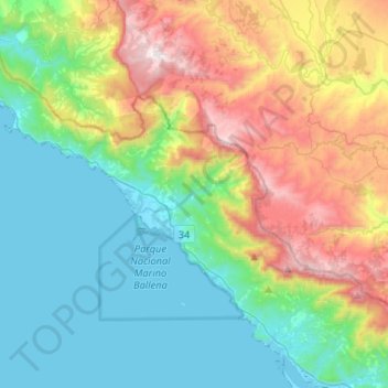
Name: Topografische Karte Bahía Ballena, Höhe, Relief.
Durchschnittliche Höhe: 384 m
Minimale Höhe: -2 m
Maximale Höhe: 1.258 m
Andere topografische Karten
Klicken Sie auf eine Karte, um ihre Topografie, ihre Höhe und ihr Relief anzuzeigen.
Ojochal
Costa Rica > Cantón Osa > Puerto Cortés
Ojochal, Puerto Cortés, Cantón Osa, Provincia Puntarenas, 60501, Costa Rica
Durchschnittliche Höhe: 88 m
Sierpe
Sierpe, Cantón Osa, Provincia Puntarenas, 60503, Costa Rica
Durchschnittliche Höhe: 84 m
Playa Hermosa
Costa Rica > Cantón Osa > Bahía Ballena
Playa Hermosa, Bahía Ballena, Cantón Osa, Provincia Puntarenas, 60504, Costa Rica
Durchschnittliche Höhe: 137 m
Parque Nacional Marino Ballena
Costa Rica > Cantón Osa > Bahía Ballena
Parque Nacional Marino Ballena, Bahía Ballena, Cantón Osa, Provincia Puntarenas, 60504, Costa Rica
Durchschnittliche Höhe: 25 m
Olla 0
Costa Rica > Cantón Osa > Palmar > Olla 0
Olla 0, Palmar, Cantón Osa, Provincia Puntarenas, 60502, Costa Rica
Durchschnittliche Höhe: 116 m
Isla del Caño
Costa Rica > Cantón Osa > Bahía Drake
Isla del Caño, Bahía Drake, Cantón Osa, Provincia Puntarenas, 60506, Costa Rica
Durchschnittliche Höhe: 22 m
Puerto Cortés
Puerto Cortés, Cantón Osa, Provincia Puntarenas, 60501, Costa Rica
Durchschnittliche Höhe: 327 m
Palmar Norte
Costa Rica > Cantón Osa > Palmar > Palmar Norte
Palmar Norte, Palmar, Cantón Osa, Provincia Puntarenas, 60502, Costa Rica
Durchschnittliche Höhe: 93 m