
Spenden
Rüste dich für dein nächstes Abenteuer:
Als Amazon-Partner verdient diese Website an qualifizierten Käufen, ohne zusätzliche Kosten für Sie.
Topografische Karte Calnali
Klicken Sie auf die Karte, um die Höhe anzuzeigen.
Spenden
Rüste dich für dein nächstes Abenteuer:
Als Amazon-Partner verdient diese Website an qualifizierten Käufen, ohne zusätzliche Kosten für Sie.
Calnali
Calnali se localiza al norte del territorio hidalguense entre los paralelos 20° 50’ y 20° 59’ de latitud norte; los meridianos 98° 25’ y 98° 41’ de longitud oeste; con una altitud entre 200 y 1800 m s. n. m. Este municipio cuenta con una superficie de 211.01 km², y representa el 1.01 % de la superficie del estado; dentro de los límites de las regiones geográficas de la Sierra Alta y la Huasteca.
Spenden
Rüste dich für dein nächstes Abenteuer:
Als Amazon-Partner verdient diese Website an qualifizierten Käufen, ohne zusätzliche Kosten für Sie.
Über diese Karte
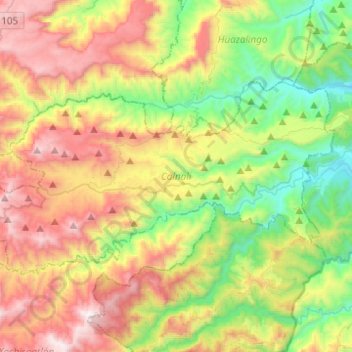
Name: Topografische Karte Calnali, Höhe, Relief.
Ort: Calnali, Hidalgo, México (20.83972 -98.66924 20.96893 -98.42221)
Durchschnittliche Höhe: 868 m
Minimale Höhe: 222 m
Maximale Höhe: 1.779 m
Spenden
Rüste dich für dein nächstes Abenteuer:
Als Amazon-Partner verdient diese Website an qualifizierten Käufen, ohne zusätzliche Kosten für Sie.
Andere topografische Karten
Klicken Sie auf eine Karte, um ihre Topografie, ihre Höhe und ihr Relief anzuzeigen.
Pachuca
México > Hidalgo > Pachuca de Soto
Le corresponden las coordenadas geográficas 20° 07’ 18” de latitud norte y 98° 44’ 09” de longitud oeste; además de contar una altitud entre 2382 y 2400 metros sobre el nivel del mar. En 2015 registró un índice de desarrollo humano de 0.834 (Muy Alto); ocupando el segundo lugar a nivel…
Durchschnittliche Höhe: 2.459 m
Spenden
Rüste dich für dein nächstes Abenteuer:
Als Amazon-Partner verdient diese Website an qualifizierten Käufen, ohne zusätzliche Kosten für Sie.
Pedregal de San Francisco
México > Hidalgo > Tulancingo de Bravo > Fraccionamiento del Magisterio Tulancinguense
Durchschnittliche Höhe: 2.181 m
Spenden
Rüste dich für dein nächstes Abenteuer:
Als Amazon-Partner verdient diese Website an qualifizierten Käufen, ohne zusätzliche Kosten für Sie.
Spenden
Rüste dich für dein nächstes Abenteuer:
Als Amazon-Partner verdient diese Website an qualifizierten Käufen, ohne zusätzliche Kosten für Sie.
Spenden
Rüste dich für dein nächstes Abenteuer:
Als Amazon-Partner verdient diese Website an qualifizierten Käufen, ohne zusätzliche Kosten für Sie.
Mineral del Chico
México > Hidalgo > Mineral del Chico
Se encuentra en la región geográfica de la Comarca Minera, en la Sierra de Pachuca; a la localidad le corresponden las coordenadas geográficas 20° 12’ 56.054” de latitud norte y 98° 43’ 52.424” de longitud oeste, con una altitud de 2358 m s. n. m. Cuenta con un clima templado subhúmedo con…
Durchschnittliche Höhe: 2.510 m
Spenden
Rüste dich für dein nächstes Abenteuer:
Als Amazon-Partner verdient diese Website an qualifizierten Käufen, ohne zusätzliche Kosten für Sie.
Spenden
Rüste dich für dein nächstes Abenteuer:
Als Amazon-Partner verdient diese Website an qualifizierten Käufen, ohne zusätzliche Kosten für Sie.
Spenden
Rüste dich für dein nächstes Abenteuer:
Als Amazon-Partner verdient diese Website an qualifizierten Käufen, ohne zusätzliche Kosten für Sie.
Spenden
Rüste dich für dein nächstes Abenteuer:
Als Amazon-Partner verdient diese Website an qualifizierten Käufen, ohne zusätzliche Kosten für Sie.
Spenden
Rüste dich für dein nächstes Abenteuer:
Als Amazon-Partner verdient diese Website an qualifizierten Käufen, ohne zusätzliche Kosten für Sie.
Spenden
Rüste dich für dein nächstes Abenteuer:
Als Amazon-Partner verdient diese Website an qualifizierten Käufen, ohne zusätzliche Kosten für Sie.
Spenden
Rüste dich für dein nächstes Abenteuer:
Als Amazon-Partner verdient diese Website an qualifizierten Käufen, ohne zusätzliche Kosten für Sie.
Residencial San Andŕes
México > Hidalgo > Tulancingo de Bravo > Jaltepec
Durchschnittliche Höhe: 2.154 m
Spenden
Rüste dich für dein nächstes Abenteuer:
Als Amazon-Partner verdient diese Website an qualifizierten Käufen, ohne zusätzliche Kosten für Sie.
Dos Cerros
México > Hidalgo > Mixquiahuala de Juárez > Colonia Veracruz
Durchschnittliche Höhe: 1.994 m
Ciudad Sahagún
México > Hidalgo > Tepeapulco
Se encuentra en los llanos de Apan, le corresponden las coordenadas geográficas 19° 46’ 21.741” de latitud norte y 98° 34’ 54.852” de longitud oeste, con una altitud de 2448 m s. n. m. Cuenta con un clima semiseco templado y templado subhúmedo con lluvias en verano, de menor humedad.
Durchschnittliche Höhe: 2.497 m
Spenden
Rüste dich für dein nächstes Abenteuer:
Als Amazon-Partner verdient diese Website an qualifizierten Käufen, ohne zusätzliche Kosten für Sie.
Spenden
Rüste dich für dein nächstes Abenteuer:
Als Amazon-Partner verdient diese Website an qualifizierten Käufen, ohne zusätzliche Kosten für Sie.
Parque Nacional El Chico
México > Hidalgo > Mineral del Chico > Mineral del Chico
Durchschnittliche Höhe: 2.761 m
Spenden
Rüste dich für dein nächstes Abenteuer:
Als Amazon-Partner verdient diese Website an qualifizierten Käufen, ohne zusätzliche Kosten für Sie.
Centro de Desarrollo Cd. Sahagún
México > Hidalgo > Tepeapulco > Ciudad Sahagún
Durchschnittliche Höhe: 2.459 m
Spenden
Rüste dich für dein nächstes Abenteuer:
Als Amazon-Partner verdient diese Website an qualifizierten Käufen, ohne zusätzliche Kosten für Sie.
Spenden
Rüste dich für dein nächstes Abenteuer:
Als Amazon-Partner verdient diese Website an qualifizierten Käufen, ohne zusätzliche Kosten für Sie.
Spenden
Rüste dich für dein nächstes Abenteuer:
Als Amazon-Partner verdient diese Website an qualifizierten Käufen, ohne zusätzliche Kosten für Sie.
Colonia Felipe Ángeles
México > Hidalgo > Santiago Tulantepec de Lugo Guerrero
Durchschnittliche Höhe: 2.259 m
Santiago Tulantepec
México > Hidalgo > Santiago Tulantepec de Lugo Guerrero
Se encuentra en la región geográfica del Valle de Tulancingo. A la localidad le corresponden las coordenadas geográficas 20°2′23″ de latitud norte y 98°21′27″ de longitud oeste, con una altitud de 2174 m s. n. m. Se localiza a una distancia de 51 kilómetros de Pachuca de Soto.
Durchschnittliche Höhe: 2.260 m
Spenden
Rüste dich für dein nächstes Abenteuer:
Als Amazon-Partner verdient diese Website an qualifizierten Käufen, ohne zusätzliche Kosten für Sie.
Spenden
Rüste dich für dein nächstes Abenteuer:
Als Amazon-Partner verdient diese Website an qualifizierten Käufen, ohne zusätzliche Kosten für Sie.
Spenden
Rüste dich für dein nächstes Abenteuer:
Als Amazon-Partner verdient diese Website an qualifizierten Käufen, ohne zusätzliche Kosten für Sie.
Spenden
Rüste dich für dein nächstes Abenteuer:
Als Amazon-Partner verdient diese Website an qualifizierten Käufen, ohne zusätzliche Kosten für Sie.
Spenden
Rüste dich für dein nächstes Abenteuer:
Als Amazon-Partner verdient diese Website an qualifizierten Käufen, ohne zusätzliche Kosten für Sie.
Spenden
Rüste dich für dein nächstes Abenteuer:
Als Amazon-Partner verdient diese Website an qualifizierten Käufen, ohne zusätzliche Kosten für Sie.
Spenden
Rüste dich für dein nächstes Abenteuer:
Als Amazon-Partner verdient diese Website an qualifizierten Käufen, ohne zusätzliche Kosten für Sie.