
Topografische Karte Town of Irondequoit
Interaktive Karte
Klicken Sie auf die Karte, um die Höhe anzuzeigen.
Über diese Karte
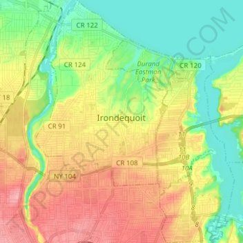
Name: Topografische Karte Town of Irondequoit, Höhe, Relief.
Ort: Town of Irondequoit, Monroe County, New York, United States (43.16667 -77.62319 43.25704 -77.52184)
Durchschnittliche Höhe: 110 m
Minimale Höhe: 68 m
Maximale Höhe: 163 m
Andere topografische Karten
Klicken Sie auf eine Karte, um ihre Topografie, ihre Höhe und ihr Relief anzuzeigen.
Town of Riga
United States > New York > Monroe County
Town of Riga, Monroe County, New York, 14428, United States
Durchschnittliche Höhe: 185 m
Belcoda
United States > New York > Monroe County
Belcoda, Town of Wheatland, Monroe County, New York, 14511, United States
Durchschnittliche Höhe: 196 m
Town of Penfield
United States > New York > Monroe County
Town of Penfield, Monroe County, New York, United States
Durchschnittliche Höhe: 135 m
Ellison Park
United States > New York > Monroe County > Penfield
Ellison Park, Brighton, Penfield, Monroe County, New York, United States
Durchschnittliche Höhe: 112 m
Pittsford
United States > New York > Monroe County > Pittsford
Pittsford, Monroe County, New York, United States
Durchschnittliche Höhe: 147 m
Town of Webster
United States > New York > Monroe County
Town of Webster, Monroe County, New York, 14580, United States
Durchschnittliche Höhe: 111 m
City of Rochester
United States > New York > Monroe County
City of Rochester, Monroe County, New York, United States
Durchschnittliche Höhe: 129 m
Village of Spencerport
United States > New York > Monroe County
Village of Spencerport, Town of Ogden, Monroe County, New York, 14559, United States
Durchschnittliche Höhe: 164 m