
Topografische Karte Atta
Klicken Sie auf die Karte, um die Höhe anzuzeigen.
Über diese Karte
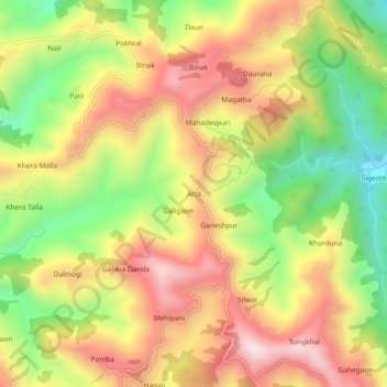
Name: Topografische Karte Atta, Höhe, Relief.
Durchschnittliche Höhe: 1.004 m
Minimale Höhe: 670 m
Maximale Höhe: 1.316 m
Andere topografische Karten
Klicken Sie auf eine Karte, um ihre Topografie, ihre Höhe und ihr Relief anzuzeigen.
Elephant Pound Rajaji National park Uttrakhand
India > Uttarakhand > Yamkeshwar
Durchschnittliche Höhe: 455 m
Elephant Pound Rajaji National park Uttrakhand
India > Uttarakhand > Yamkeshwar
Durchschnittliche Höhe: 455 m
Elephant Pound Rajaji National park Uttrakhand
India > Uttarakhand > Yamkeshwar
Durchschnittliche Höhe: 455 m
Elephant Pound Rajaji National park Uttrakhand
India > Uttarakhand > Yamkeshwar
Durchschnittliche Höhe: 455 m
Elephant Pound Rajaji National park Uttrakhand
India > Uttarakhand > Yamkeshwar
Durchschnittliche Höhe: 455 m