
Topografische Karte Mszalnica
Interaktive Karte
Klicken Sie auf die Karte, um die Höhe anzuzeigen.
Über diese Karte
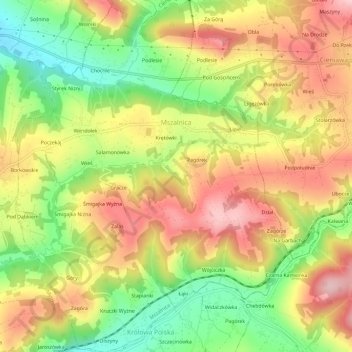
Name: Topografische Karte Mszalnica, Höhe, Relief.
Durchschnittliche Höhe: 474 m
Minimale Höhe: 362 m
Maximale Höhe: 578 m
Andere topografische Karten
Klicken Sie auf eine Karte, um ihre Topografie, ihre Höhe und ihr Relief anzuzeigen.
Ptaszkowa
Poland > Lesser Poland Voivodeship > Nowy Sącz County
Ptaszkowa, gmina Grybów, Nowy Sącz County, Lesser Poland Voivodeship, 33-333, Poland
Durchschnittliche Höhe: 534 m
Zabrzeż
Poland > Lesser Poland Voivodeship > Nowy Sącz County
Zabrzeż, gmina Łącko, Nowy Sącz County, Lesser Poland Voivodeship, Poland
Durchschnittliche Höhe: 479 m
Święty Krzyż
Poland > Lesser Poland Voivodeship > Nowy Sącz County > Królowa Polska > Góry
Święty Krzyż, Granica, Góry, Królowa Polska, gmina Kamionka Wielka, Nowy Sącz County, Lesser Poland Voivodeship, 33-334, Poland
Durchschnittliche Höhe: 463 m
Grybów
Poland > Lesser Poland Voivodeship > Nowy Sącz County > Grybów
Grybów, Nowy Sącz County, Lesser Poland Voivodeship, Poland
Durchschnittliche Höhe: 433 m