
Spenden
Rüste dich für dein nächstes Abenteuer:
Als Amazon-Partner verdient diese Website an qualifizierten Käufen, ohne zusätzliche Kosten für Sie.
Topografische Karte Clarkston
Klicken Sie auf die Karte, um die Höhe anzuzeigen.
Spenden
Rüste dich für dein nächstes Abenteuer:
Als Amazon-Partner verdient diese Website an qualifizierten Käufen, ohne zusätzliche Kosten für Sie.
Clarkston
The townsite of Clarkston was laid out in 1864. It was named for Israel Justus Clark, who was an early settler and the first branch president of the Church of Jesus Christ of Latter-day Saints in Clarkston. The settlers originally settled east of modern-day Clarkston in a spot known as the flat. Due to water quality concerns and sickness, they moved the town to a higher elevation and closer to City Creek and other springs. They also experimented in dry farming, mainly north of town. There was trouble with the native Americans, and in 1866 the settlement was abandoned for a short time. Eventually, an agreement was made between the settlers and Indian John, a chief under the Washakie. A Latter-day Saint ward was organized in Clarkston in the fall of 1867 with William F. Rigby as bishop. A brick meetinghouse was built in 1910. In 1930 Clarkston had a population of 570. Among the first settlers were Israel J. Clark, James Myler, William Ricks, Michael Poulsen, Johannis Dahle, Gideon Harmison, David Cook, John Griffiths, John Griffin, John Godfrey, Samuel Whitney, Ole S. Jensen and their families; also the Thompson and Hansen families, A. W. Heggie, a Mr. Parker, Paul Paulson, Andrew McCombs, Simon Smith, Isaac Cook, A. H. Atkinson, and others. The existence of the Clarkston settlement was threatened in 1869 when a majority of the settlers, due mainly to discouragement because of the severe winters and heavy drifting snow, decided to move to the present site of Newton, Utah. But a few people decided to stay in Clarkston, and some who had left returned, and the settlement became a permanent one. There was a controversy over retaining the name Clarkston for the original settlement or transferring it to the "New Town."
Spenden
Rüste dich für dein nächstes Abenteuer:
Als Amazon-Partner verdient diese Website an qualifizierten Käufen, ohne zusätzliche Kosten für Sie.
Über diese Karte
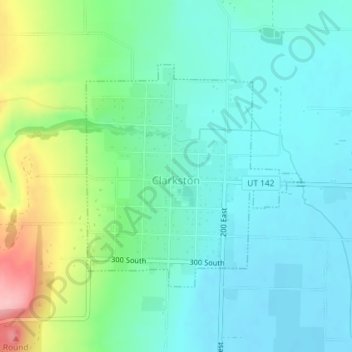
Name: Topografische Karte Clarkston, Höhe, Relief.
Ort: Clarkston, Cache County, Utah, 84305, United States (41.91193 -112.05931 41.92900 -112.03706)
Durchschnittliche Höhe: 1.498 m
Minimale Höhe: 1.458 m
Maximale Höhe: 1.616 m
Spenden
Rüste dich für dein nächstes Abenteuer:
Als Amazon-Partner verdient diese Website an qualifizierten Käufen, ohne zusätzliche Kosten für Sie.
Andere topografische Karten
Klicken Sie auf eine Karte, um ihre Topografie, ihre Höhe und ihr Relief anzuzeigen.
Spenden
Rüste dich für dein nächstes Abenteuer:
Als Amazon-Partner verdient diese Website an qualifizierten Käufen, ohne zusätzliche Kosten für Sie.