
Topografische Karte Neapoli Municipal Unit
Interaktive Karte
Klicken Sie auf die Karte, um die Höhe anzuzeigen.
Über diese Karte
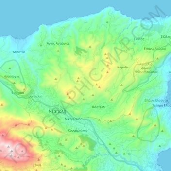
Name: Topografische Karte Neapoli Municipal Unit, Höhe, Relief.
Durchschnittliche Höhe: 332 m
Minimale Höhe: -1 m
Maximale Höhe: 1.477 m
Andere topografische Karten
Klicken Sie auf eine Karte, um ihre Topografie, ihre Höhe und ihr Relief anzuzeigen.
Anemomilia
Greece > Region of Crete > Lasithi Regional Unit > Sitia Municipal Unit
Anemomilia, Community of Sitia, Sitia Municipal Unit, Municipality of Sitia, Lasithi Regional Unit, Region of Crete, 723 00, Greece
Durchschnittliche Höhe: 54 m
Sitia Municipal Unit
Greece > Region of Crete > Lasithi Regional Unit
Sitia Municipal Unit, Municipality of Sitia, Lasithi Regional Unit, Region of Crete, Greece
Durchschnittliche Höhe: 163 m
Agios Nikolaos
Greece > Region of Crete > Lasithi Regional Unit > Agios Nikolaos Municipal Unit
Agios Nikolaos, Agios Nikolaos Municipal Unit, Municipality of Agios Nikolaos, Lasithi Regional Unit, Region of Crete, 721 00, Greece
Durchschnittliche Höhe: 70 m
Sitia
Greece > Region of Crete > Lasithi Regional Unit > Sitia Municipal Unit
Sitia, Sitia Municipal Unit, Municipality of Sitia, Lasithi Regional Unit, Region of Crete, 723 00, Greece
Durchschnittliche Höhe: 64 m
Ierapetra
Greece > Region of Crete > Lasithi Regional Unit > Ierapetra Municipal Unit
Ierapetra, Ierapetra Municipal Unit, Municipality of Ierapetra, Lasithi Regional Unit, Region of Crete, 722 00, Greece
Durchschnittliche Höhe: 35 m