
Topografische Karte Draché
Interaktive Karte
Klicken Sie auf die Karte, um die Höhe anzuzeigen.
Über diese Karte
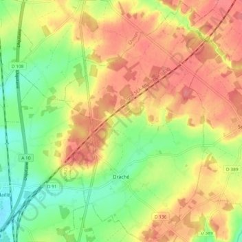
Name: Topografische Karte Draché, Höhe, Relief.
Durchschnittliche Höhe: 85 m
Minimale Höhe: 46 m
Maximale Höhe: 118 m
La Manse, d'une longueur totale de 30,5 km, prend sa source à une altitude de 117 m sur la commune de Bossée et se jette dans la Vienne à L'Île-Bouchard, à 32 m d'altitude, après avoir traversé 11 communes. Sur le plan piscicole, la Manse est classée en deuxième catégorie piscicole. Le groupe biologique dominant est constitué essentiellement de poissons blancs (cyprinidés) et de carnassiers (brochet, sandre et perche).
Andere topografische Karten
Klicken Sie auf eine Karte, um ihre Topografie, ihre Höhe und ihr Relief anzuzeigen.
Cheillé
France > Centre-Val de Loire > Indre-et-Loire
Cheillé, Tours, Indre-et-Loire, Centre-Val de Loire, France métropolitaine, 37190, France
Durchschnittliche Höhe: 91 m
Descartes
France > Centre-Val de Loire > Indre-et-Loire
Descartes, Loches, Indre-et-Loire, Centre-Val de Loire, France métropolitaine, 37160, France
Durchschnittliche Höhe: 90 m
Le Liège
France > Centre-Val de Loire > Indre-et-Loire
Le Liège, Loches, Indre-et-Loire, Centre-Val de Loire, France métropolitaine, 37460, France
Durchschnittliche Höhe: 119 m
Tours
France > Centre-Val de Loire > Indre-et-Loire
Tours, Indre-et-Loire, Centre-Val de Loire, France métropolitaine, France
Durchschnittliche Höhe: 73 m
Luzillé
France > Centre-Val de Loire > Indre-et-Loire
Luzillé, Loches, Indre-et-Loire, Centre-Val de Loire, France métropolitaine, 37150, France
Durchschnittliche Höhe: 106 m
La Ville
France > Centre-Val de Loire > Indre-et-Loire > Sainte-Maure-de-Touraine
La Ville, Sainte-Maure-de-Touraine, Chinon, Indre-et-Loire, Centre-Val de Loire, France métropolitaine, 37800, France
Durchschnittliche Höhe: 97 m
Château
France > Centre-Val de Loire > Indre-et-Loire > Sainte-Maure-de-Touraine > La Ville
Château, Rue du Château, La Ville, Sainte-Maure-de-Touraine, Chinon, Indre-et-Loire, Centre-Val de Loire, France métropolitaine, 37800, France
Durchschnittliche Höhe: 92 m
Les Évées
France > Centre-Val de Loire > Indre-et-Loire > Saint-Martin-le-Beau
Les Évées, Saint-Martin-le-Beau, Loches, Indre-et-Loire, Centre-Val de Loire, France métropolitaine, 37270, France
Durchschnittliche Höhe: 71 m
Courçay
France > Centre-Val de Loire > Indre-et-Loire
Courçay, Loches, Indre-et-Loire, Centre-Val de Loire, France métropolitaine, 37310, France
Durchschnittliche Höhe: 87 m
Monts
France > Centre-Val de Loire > Indre-et-Loire
Monts, Tours, Indre-et-Loire, Centre-Val de Loire, France métropolitaine, 37260, France
Durchschnittliche Höhe: 81 m
Saint-Pierre-des-Corps
France > Centre-Val de Loire > Indre-et-Loire
Saint-Pierre-des-Corps, Arrondissement de Tours, Indre-et-Loire, Centre-Val de Loire, France métropolitaine, 37700, France
Durchschnittliche Höhe: 55 m
Tours
France > Centre-Val de Loire > Indre-et-Loire > Tours
Tours, Indre-et-Loire, Centre-Val de Loire, France métropolitaine, 37000, France
Durchschnittliche Höhe: 91 m
Marolle
France > Centre-Val de Loire > Indre-et-Loire > Genillé
Marolle, Genillé, Loches, Indre-et-Loire, Centre-Val de Loire, France métropolitaine, 37460, France
Durchschnittliche Höhe: 122 m
Les Quarts
France > Centre-Val de Loire > Indre-et-Loire > Montbazon
Les Quarts, Montbazon, Arrondissement de Tours, Indre-et-Loire, Centre-Val de Loire, France métropolitaine, 37250, France
Durchschnittliche Höhe: 78 m
Yzeures-sur-Creuse
France > Centre-Val de Loire > Indre-et-Loire
Yzeures-sur-Creuse, Loches, Indre-et-Loire, Centre-Val de Loire, France métropolitaine, 37290, France
Durchschnittliche Höhe: 95 m
Tour Heurtault
France > Centre-Val de Loire > Indre-et-Loire > Amboise > La Ville-Sud
Tour Heurtault, Place Michel Debré, Quai du Maréchal Joffre, La Ville-Sud, Amboise, Loches, Indre-et-Loire, Centre-Val de Loire, France métropolitaine, 37400, France
Durchschnittliche Höhe: 71 m
Cinais
France > Centre-Val de Loire > Indre-et-Loire > Cinais
Cinais, Chinon, Indre-et-Loire, Centre-Val de Loire, France métropolitaine, 37500, France
Durchschnittliche Höhe: 49 m
Loches
France > Centre-Val de Loire > Indre-et-Loire
Loches, Indre-et-Loire, Centre-Val de Loire, France métropolitaine, 37600, France
Durchschnittliche Höhe: 106 m
Richelieu
France > Centre-Val de Loire > Indre-et-Loire
Richelieu, Chinon, Indre-et-Loire, Centre-Val de Loire, France métropolitaine, 37120, France
Durchschnittliche Höhe: 62 m
Langeais
France > Centre-Val de Loire > Indre-et-Loire > Langeais
Langeais, Chinon, Indre-et-Loire, Centre-Val de Loire, France métropolitaine, 37130, France
Durchschnittliche Höhe: 82 m
Villaines-les-Rochers
France > Centre-Val de Loire > Indre-et-Loire
Villaines-les-Rochers, Arrondissement de Tours, Indre-et-Loire, Centre-Val de Loire, France métropolitaine, 37190, France
Durchschnittliche Höhe: 97 m