
Topografische Karte North Bethlehem
Interaktive Karte
Klicken Sie auf die Karte, um die Höhe anzuzeigen.
Über diese Karte
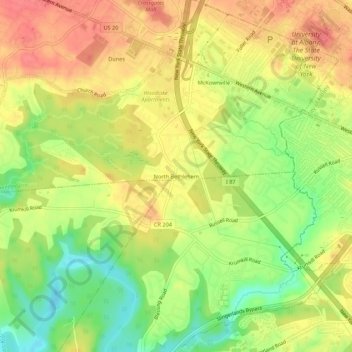
Name: Topografische Karte North Bethlehem, Höhe, Relief.
Durchschnittliche Höhe: 65 m
Minimale Höhe: 28 m
Maximale Höhe: 93 m
Andere topografische Karten
Klicken Sie auf eine Karte, um ihre Topografie, ihre Höhe und ihr Relief anzuzeigen.
Westmere
United States > New York > Albany County > Town of Guilderland
Westmere, Town of Guilderland, Albany County, New York, United States
Durchschnittliche Höhe: 79 m
Village of Altamont
United States > New York > Albany County > Town of Guilderland
Village of Altamont, Town of Guilderland, Albany County, New York, United States
Durchschnittliche Höhe: 158 m
Fort Hunter
United States > New York > Albany County > Town of Guilderland
Fort Hunter, Town of Guilderland, Albany County, New York, 12303, United States
Durchschnittliche Höhe: 99 m
Meadowdale
United States > New York > Albany County > Town of Guilderland
Meadowdale, Town of Guilderland, Albany County, New York, 12085, United States
Durchschnittliche Höhe: 115 m
Dunnsville
United States > New York > Albany County > Town of Guilderland
Dunnsville, Town of Guilderland, Albany County, New York, 12009, United States
Durchschnittliche Höhe: 130 m
Fullers
United States > New York > Albany County > Town of Guilderland
Fullers, Town of Guilderland, Albany County, New York, 12085, United States
Durchschnittliche Höhe: 90 m
Hartmans Corners
United States > New York > Albany County > Town of Guilderland
Hartmans Corners, Town of Guilderland, Albany County, New York, 12084, United States
Durchschnittliche Höhe: 81 m
Guilderland Center
United States > New York > Albany County > Town of Guilderland
Guilderland Center, Town of Guilderland, Albany County, New York, 12085, United States
Durchschnittliche Höhe: 96 m