
Topografische Karte El Ouricia
Interaktive Karte
Klicken Sie auf die Karte, um die Höhe anzuzeigen.
Über diese Karte
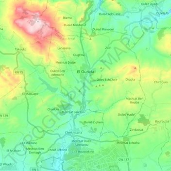
Name: Topografische Karte El Ouricia, Höhe, Relief.
Ort: El Ouricia, Ain Arnat District, Setif, Algeria (36.21637 5.28075 36.32506 5.47877)
Durchschnittliche Höhe: 1.179 m
Minimale Höhe: 959 m
Maximale Höhe: 1.733 m
Andere topografische Karten
Klicken Sie auf eine Karte, um ihre Topografie, ihre Höhe und ihr Relief anzuzeigen.
El Ouricia
Algeria > Setif > Ain Arnat District > El Ouricia > El Ouricia
El Ouricia, Ain Arnat District, Setif, 19047, Algeria
Durchschnittliche Höhe: 1.184 m
Aïn Arnat
Algeria > Setif > Ain Arnat District > Aïn Arnat
Aïn Arnat, Ain Arnat District, Setif, 19017, Algeria
Durchschnittliche Höhe: 1.010 m