
Vielen Dank für die Unterstützung dieser Website ❤️
Spenden
Spenden
Rüste dich für dein nächstes Abenteuer:
Als Amazon-Partner verdient diese Website an qualifizierten Käufen, ohne zusätzliche Kosten für Sie.
Topografische Karte Bell Center
Klicken Sie auf die Karte, um die Höhe anzuzeigen.
Vielen Dank für die Unterstützung dieser Website ❤️
Spenden
Spenden
Rüste dich für dein nächstes Abenteuer:
Als Amazon-Partner verdient diese Website an qualifizierten Käufen, ohne zusätzliche Kosten für Sie.
Über diese Karte
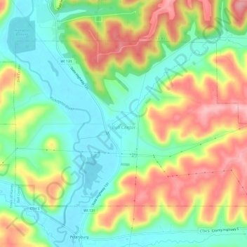
Name: Topografische Karte Bell Center, Höhe, Relief.
Durchschnittliche Höhe: 267 m
Minimale Höhe: 205 m
Maximale Höhe: 354 m
Vielen Dank für die Unterstützung dieser Website ❤️
Spenden
Spenden
Rüste dich für dein nächstes Abenteuer:
Als Amazon-Partner verdient diese Website an qualifizierten Käufen, ohne zusätzliche Kosten für Sie.
Andere topografische Karten
Klicken Sie auf eine Karte, um ihre Topografie, ihre Höhe und ihr Relief anzuzeigen.
North Clayton
United States > Wisconsin > Crawford County > Town of Clayton
Durchschnittliche Höhe: 333 m