
Topografische Karte Mount Mariveles
Interaktive Karte
Klicken Sie auf die Karte, um die Höhe anzuzeigen.
Über diese Karte
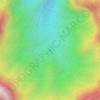
Name: Topografische Karte Mount Mariveles, Höhe, Relief.
Durchschnittliche Höhe: 879 m
Minimale Höhe: 528 m
Maximale Höhe: 1.381 m
Mount Mariveles is a massive stratovolcano topped with a 4-kilometre (2.5 mi) summit caldera which drains to the north. The highest peak, called Mariveles, has an elevation of 1,388 metres (4,554 ft) asl. Mounts Pantingan, Bataan, Tarak, and Vintana are the other peaks of the volcano-caldera complex, which has a base diameter of 22 kilometres (14 mi).
Andere topografische Karten
Klicken Sie auf eine Karte, um ihre Topografie, ihre Höhe und ihr Relief anzuzeigen.
Mariveles
Philippines > Bataan > Mariveles
Mariveles, Bataan, Central Luzon, 2105, Philippines
Durchschnittliche Höhe: 83 m
Cabcaben
Philippines > Bataan > Mariveles
Cabcaben, Mariveles, 3rd District of Bataan, Bataan, Central Luzon, 2105, Philippines
Durchschnittliche Höhe: 21 m
Laki Beach
Philippines > Bataan > Mariveles
Laki Beach, Mariveles, Bataan, Central Luzon, Philippines
Durchschnittliche Höhe: 30 m