
Topografische Karte Kanorado
Interaktive Karte
Klicken Sie auf die Karte, um die Höhe anzuzeigen.
Kanorado
On February 10, 2016 the House of Representatives of the State of Kansas passed a Resolution (Res.#6033) designating the City of Kanorado as the Top City of Kansas. This is due to it being the highest city elevation in the State of Kansas at 3,907 feet.
Über diese Karte
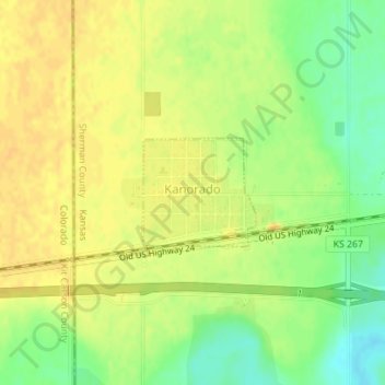
Name: Topografische Karte Kanorado, Höhe, Relief.
Ort: Kanorado, Sherman County, Kansas, United States (39.33279 -102.04204 39.34040 -102.03179)
Durchschnittliche Höhe: 1.191 m
Minimale Höhe: 1.173 m
Maximale Höhe: 1.200 m