
Topografische Karte Scarborough
Interaktive Karte
Klicken Sie auf die Karte, um die Höhe anzuzeigen.
Über diese Karte
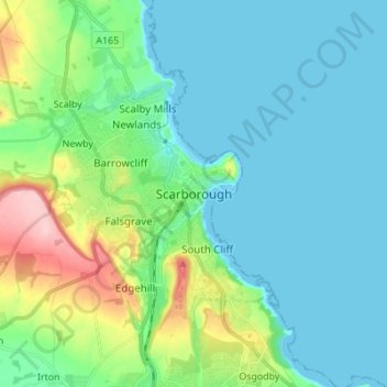
Name: Topografische Karte Scarborough, Höhe, Relief.
Durchschnittliche Höhe: 39 m
Minimale Höhe: -1 m
Maximale Höhe: 184 m
The climate is temperate with mild summers and cool, windy, winters. The hottest months of the year are July and August, with temperatures reaching an average high of 17 °C and falling to 11 °C at night. The average daytime temperatures in January are 4 °C, falling to 1 °C at night. The station's elevation of 110 m (360 ft) is far above sea level compared to the immediate coastline, where the climate is likely slightly milder year round.
Andere topografische Karten
Klicken Sie auf eine Karte, um ihre Topografie, ihre Höhe und ihr Relief anzuzeigen.
Isle of Man
United Kingdom > England > North Yorkshire > Crathorne
Isle of Man, Crathorne, North Yorkshire, England, United Kingdom
Durchschnittliche Höhe: 65 m
Malton
United Kingdom > England > North Yorkshire
Malton, North Yorkshire, England, United Kingdom
Durchschnittliche Höhe: 28 m
Longdales
United Kingdom > England > North Yorkshire
Longdales, Kettlewell with Starbotton, North Yorkshire, England, United Kingdom
Durchschnittliche Höhe: 436 m
Laverton
United Kingdom > England > North Yorkshire
Laverton, North Yorkshire, England, United Kingdom
Durchschnittliche Höhe: 172 m
Whitby
United Kingdom > England > North Yorkshire
Whitby, North Yorkshire, England, United Kingdom
Durchschnittliche Höhe: 37 m
Dalby
United Kingdom > England > North Yorkshire > Hambleton
Dalby, Dalby-cum-Skewsby, Hambleton, North Yorkshire, England, YO60 6PF, United Kingdom
Durchschnittliche Höhe: 80 m
Carlton in Cleveland
United Kingdom > England > North Yorkshire > Hambleton
Great Busby, Carlton in Cleveland, Hambleton, North Yorkshire, England, United Kingdom
Durchschnittliche Höhe: 112 m
Hunter Hill
United Kingdom > England > North Yorkshire > Craven District
Hunter Hill, Craven District, North Yorkshire, England, BD24 0JB, United Kingdom
Durchschnittliche Höhe: 312 m
East Rounton
United Kingdom > England > North Yorkshire > Hambleton
East Rounton, Hambleton, North Yorkshire, England, United Kingdom
Durchschnittliche Höhe: 65 m
Selby
United Kingdom > England > North Yorkshire > Selby
Selby, North Yorkshire, England, United Kingdom
Durchschnittliche Höhe: 7 m
Middleham
United Kingdom > England > North Yorkshire > Richmondshire > Middleham
Middleham, Richmondshire, North Yorkshire, Yorkshire and the Humber, England, United Kingdom
Durchschnittliche Höhe: 157 m
Cave Hill
United Kingdom > England > North Yorkshire > Craven
Cave Hill, Craven, North Yorkshire, Yorkshire and the Humber, England, BD24 0JQ, United Kingdom
Durchschnittliche Höhe: 351 m
Leyburn
United Kingdom > England > North Yorkshire > Richmondshire > Leyburn
Leyburn, Richmondshire, North Yorkshire, Yorkshire and the Humber, England, United Kingdom
Durchschnittliche Höhe: 195 m
Skipton
United Kingdom > England > North Yorkshire > Craven District
Skipton, Craven District, North Yorkshire, England, United Kingdom
Durchschnittliche Höhe: 173 m
Rylstone
United Kingdom > England > North Yorkshire > Craven > Rylstone
Rylstone, Craven, North Yorkshire, Yorkshire and the Humber, England, BD23 6LH, United Kingdom
Durchschnittliche Höhe: 236 m
Hill Top
United Kingdom > England > North Yorkshire
Hill Top, North Yorkshire, England, BD23 6PP, United Kingdom
Durchschnittliche Höhe: 231 m
Ouse
United Kingdom > England > North Yorkshire
Ouse, North Yorkshire, England, YO1 7DP, United Kingdom
Durchschnittliche Höhe: 18 m