
Spenden
Rüste dich für dein nächstes Abenteuer:
Als Amazon-Partner verdient diese Website an qualifizierten Käufen, ohne zusätzliche Kosten für Sie.
Topografische Karte Nocatee
Klicken Sie auf die Karte, um die Höhe anzuzeigen.
Spenden
Rüste dich für dein nächstes Abenteuer:
Als Amazon-Partner verdient diese Website an qualifizierten Käufen, ohne zusätzliche Kosten für Sie.
Über diese Karte
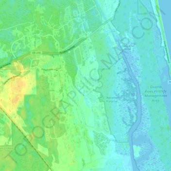
Name: Topografische Karte Nocatee, Höhe, Relief.
Ort: Nocatee, Saint Johns County, Florida, 32081, United States (30.04711 -81.48076 30.14394 -81.36572)
Durchschnittliche Höhe: 7 m
Minimale Höhe: -5 m
Maximale Höhe: 22 m
Spenden
Rüste dich für dein nächstes Abenteuer:
Als Amazon-Partner verdient diese Website an qualifizierten Käufen, ohne zusätzliche Kosten für Sie.
Andere topografische Karten
Klicken Sie auf eine Karte, um ihre Topografie, ihre Höhe und ihr Relief anzuzeigen.
Ponte Vedra Beach
United States > Florida > Saint Johns County > Ponte Vedra Beach
Ponte Vedra Beach is characterized by its gently rolling terrain that is primarily flat and lies only about 15 feet above sea level. The landscape is predominantly shaped by coastal dunes and the proximity to the Atlantic Ocean, resulting in sandy beaches interspersed with vegetation typical of barrier island…
Durchschnittliche Höhe: 3 m
Spenden
Rüste dich für dein nächstes Abenteuer:
Als Amazon-Partner verdient diese Website an qualifizierten Käufen, ohne zusätzliche Kosten für Sie.
Butler Beach
United States > Florida > Saint Johns County > Saint Augustine Beach
Durchschnittliche Höhe: 3 m
Spenden
Rüste dich für dein nächstes Abenteuer:
Als Amazon-Partner verdient diese Website an qualifizierten Käufen, ohne zusätzliche Kosten für Sie.
West Augustine
United States > Florida > Saint Johns County > Saint Augustine
Durchschnittliche Höhe: 6 m
Butler Beach
United States > Florida > Saint Johns County > Saint Augustine Beach
Durchschnittliche Höhe: 2 m
Spenden
Rüste dich für dein nächstes Abenteuer:
Als Amazon-Partner verdient diese Website an qualifizierten Käufen, ohne zusätzliche Kosten für Sie.
Villano Beach
United States > Florida > Saint Johns County > Villano Beach
Durchschnittliche Höhe: 1 m
Spenden
Rüste dich für dein nächstes Abenteuer:
Als Amazon-Partner verdient diese Website an qualifizierten Käufen, ohne zusätzliche Kosten für Sie.
Spenden
Rüste dich für dein nächstes Abenteuer:
Als Amazon-Partner verdient diese Website an qualifizierten Käufen, ohne zusätzliche Kosten für Sie.
Butler Beach
United States > Florida > Saint Johns County > Saint Augustine
Durchschnittliche Höhe: 3 m
Anastasia Island
United States > Florida > Saint Johns County > Saint Augustine
Durchschnittliche Höhe: 4 m
Spenden
Rüste dich für dein nächstes Abenteuer:
Als Amazon-Partner verdient diese Website an qualifizierten Käufen, ohne zusätzliche Kosten für Sie.
Fort Peyton
United States > Florida > Saint Johns County > Saint Augustine
Durchschnittliche Höhe: 11 m
Ponte Vedra Beach
United States > Florida > Saint Johns County > Ponte Vedra Beach
Durchschnittliche Höhe: 3 m
Spenden
Rüste dich für dein nächstes Abenteuer:
Als Amazon-Partner verdient diese Website an qualifizierten Käufen, ohne zusätzliche Kosten für Sie.
Lincolnville
United States > Florida > Saint Johns County > Saint Augustine
Durchschnittliche Höhe: 4 m