
Topografische Karte Horace
Interaktive Karte
Klicken Sie auf die Karte, um die Höhe anzuzeigen.
Über diese Karte
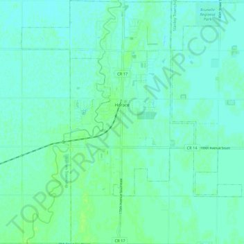
Name: Topografische Karte Horace, Höhe, Relief.
Ort: Horace, Cass County, North Dakota, United States (46.71719 -96.94762 46.79008 -96.87234)
Durchschnittliche Höhe: 278 m
Minimale Höhe: 275 m
Maximale Höhe: 283 m
Andere topografische Karten
Klicken Sie auf eine Karte, um ihre Topografie, ihre Höhe und ihr Relief anzuzeigen.
Fargo
United States > North Dakota > Cass County
Fargo, Cass County, North Dakota, United States
Durchschnittliche Höhe: 277 m
Kindred
United States > North Dakota > Cass County
Kindred, Cass County, North Dakota, United States
Durchschnittliche Höhe: 288 m
Fargo
United States > North Dakota > Cass County > Fargo
Fargo, Cass County, North Dakota, 58102-4608, United States
Durchschnittliche Höhe: 277 m
Harwood
United States > North Dakota > Cass County > Harwood
Harwood, Cass County, North Dakota, 58042, United States
Durchschnittliche Höhe: 272 m