
Topografische Karte Bedford County
Interaktive Karte
Klicken Sie auf die Karte, um die Höhe anzuzeigen.
Über diese Karte
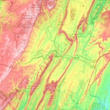
Name: Topografische Karte Bedford County, Höhe, Relief.
Ort: Bedford County, Pennsylvanie, États-Unis d'Amérique (39.72258 -78.80828 40.32703 -78.13472)
Durchschnittliche Höhe: 491 m
Minimale Höhe: 135 m
Maximale Höhe: 956 m
Andere topografische Karten
Klicken Sie auf eine Karte, um ihre Topografie, ihre Höhe und ihr Relief anzuzeigen.
Knight Lake
États-Unis d'Amérique > Pennsylvanie > Montgomery County > Upper Frederick Township
Knight Lake, Upper Frederick Township, Montgomery County, Pennsylvanie, États-Unis d'Amérique
Durchschnittliche Höhe: 95 m
Hatboro
États-Unis d'Amérique > Pennsylvanie > Montgomery County
Hatboro, Montgomery County, Pennsylvanie, 19040, États-Unis d'Amérique
Durchschnittliche Höhe: 77 m
Erie County
États-Unis d'Amérique > Pennsylvanie
Erie County, Pennsylvanie, États-Unis d'Amérique
Durchschnittliche Höhe: 248 m
Mercer County
États-Unis d'Amérique > Pennsylvanie
Mercer County, Pennsylvanie, États-Unis d'Amérique
Durchschnittliche Höhe: 362 m
Cover Hill
États-Unis d'Amérique > Pennsylvanie > Somerset County > Brothersvalley Township
Cover Hill, Brothersvalley Township, Somerset County, Pennsylvanie, 15510, États-Unis d'Amérique
Durchschnittliche Höhe: 768 m
West Gate Hills
États-Unis d'Amérique > Pennsylvanie > Delaware County > Haverford Township
West Gate Hills, Haverford Township, Delaware County, Pennsylvanie, 19083, États-Unis d'Amérique
Durchschnittliche Höhe: 86 m
Old Orchard
États-Unis d'Amérique > Pennsylvanie > Northampton County > Palmer Township > Old Orchard
Old Orchard, Palmer Township, Northampton County, Pennsylvanie, États-Unis d'Amérique
Durchschnittliche Höhe: 105 m
Lemoyne
États-Unis d'Amérique > Pennsylvanie > Cumberland County
Lemoyne, Cumberland County, Pennsylvanie, 17043, États-Unis d'Amérique
Durchschnittliche Höhe: 114 m
East Vincent Township
États-Unis d'Amérique > Pennsylvanie > Chester County
East Vincent Township, Chester County, Pennsylvanie, 19475, États-Unis d'Amérique
Durchschnittliche Höhe: 73 m
Lower Turkeyfoot Township
États-Unis d'Amérique > Pennsylvanie > Somerset County
Lower Turkeyfoot Township, Somerset County, Pennsylvanie, États-Unis d'Amérique
Durchschnittliche Höhe: 611 m
Harmarville
États-Unis d'Amérique > Pennsylvanie > Allegheny County > Harmarville
Harmarville, Harmar Township, Allegheny County, Pennsylvanie, 15139, États-Unis d'Amérique
Durchschnittliche Höhe: 287 m
Perkiomen Place
États-Unis d'Amérique > Pennsylvanie > Montgomery County > East Greenville > Perkiomen Place
Perkiomen Place, East Greenville, Montgomery County, Pennsylvanie, 18041, États-Unis d'Amérique
Durchschnittliche Höhe: 112 m
Owl Head
États-Unis d'Amérique > Pennsylvanie > Earl Township
Owl Head, Earl Township, Berks County, Pennsylvanie, 19519, États-Unis d'Amérique
Durchschnittliche Höhe: 182 m
Schuylkill County
États-Unis d'Amérique > Pennsylvanie
Schuylkill County, Pennsylvanie, États-Unis d'Amérique
Durchschnittliche Höhe: 286 m
Warren County
États-Unis d'Amérique > Pennsylvanie
Warren County, Pennsylvanie, États-Unis d'Amérique
Durchschnittliche Höhe: 500 m
Huntingdon County
États-Unis d'Amérique > Pennsylvanie
Huntingdon County, Pennsylvanie, États-Unis d'Amérique
Durchschnittliche Höhe: 380 m
Gleason
États-Unis d'Amérique > Pennsylvanie > Gleason
Gleason, Tioga County, Pennsylvanie, États-Unis d'Amérique
Durchschnittliche Höhe: 585 m
Stowe
États-Unis d'Amérique > Pennsylvanie > North Coventry Township
Stowe, Pottstown Bypass, North Coventry Township, Chester County, Pennsylvanie, 19464-0289, États-Unis d'Amérique
Durchschnittliche Höhe: 68 m
Harmar Township
États-Unis d'Amérique > Pennsylvanie > Harmar Township
Harmar Township, Allegheny County, Pennsylvanie, États-Unis d'Amérique
Durchschnittliche Höhe: 283 m
Westmont
États-Unis d'Amérique > Pennsylvanie > Westmont
Westmont, Cambria County, Pennsylvanie, États-Unis d'Amérique
Durchschnittliche Höhe: 495 m
Bethel Township
États-Unis d'Amérique > Pennsylvanie > Bethel Township
Bethel Township, Lebanon County, Pennsylvanie, 17026, États-Unis d'Amérique
Durchschnittliche Höhe: 192 m
Armstrong County
États-Unis d'Amérique > Pennsylvanie
Armstrong County, Pennsylvanie, États-Unis d'Amérique
Durchschnittliche Höhe: 388 m
Girardville
États-Unis d'Amérique > Pennsylvanie > Girardville
Girardville, Schuylkill County, Pennsylvanie, 17935, États-Unis d'Amérique
Durchschnittliche Höhe: 396 m
Big Level
États-Unis d'Amérique > Pennsylvanie
Big Level, Potter County, Pennsylvanie, États-Unis d'Amérique
Durchschnittliche Höhe: 715 m
Lees Creek
États-Unis d'Amérique > Pennsylvanie
Lees Creek, Lackawanna County, Pennsylvanie, 18433, États-Unis d'Amérique
Durchschnittliche Höhe: 352 m
Dauphin County
États-Unis d'Amérique > Pennsylvanie
Dauphin County, Pennsylvanie, États-Unis d'Amérique
Durchschnittliche Höhe: 196 m
Flat Top
États-Unis d'Amérique > Pennsylvanie
Flat Top, Wyoming County, Pennsylvanie, États-Unis d'Amérique
Durchschnittliche Höhe: 579 m
York County
États-Unis d'Amérique > Pennsylvanie
York County, Pennsylvanie, États-Unis d'Amérique
Durchschnittliche Höhe: 172 m
Berks County
États-Unis d'Amérique > Pennsylvanie
Berks County, Pennsylvanie, États-Unis d'Amérique
Durchschnittliche Höhe: 181 m
Acheson
États-Unis d'Amérique > Pennsylvanie > Washington County > Independence Township
Acheson, Independence Township, Washington County, Pennsylvanie, États-Unis d'Amérique
Durchschnittliche Höhe: 325 m
Brady Township
États-Unis d'Amérique > Pennsylvanie > Brady Township
Brady Township, Butler County, Pennsylvanie, États-Unis d'Amérique
Durchschnittliche Höhe: 398 m
Freemont
États-Unis d'Amérique > Pennsylvanie > Freemont
Freemont, Chester County, Pennsylvanie, 19362, États-Unis d'Amérique
Durchschnittliche Höhe: 115 m
Lackawanna County
États-Unis d'Amérique > Pennsylvanie
Lackawanna County, Pennsylvanie, États-Unis d'Amérique
Durchschnittliche Höhe: 431 m
Clarks Summit
États-Unis d'Amérique > Pennsylvanie > Clarks Summit
Clarks Summit, Lackawanna County, Pennsylvanie, 18411, États-Unis d'Amérique
Durchschnittliche Höhe: 411 m
Somerset County
États-Unis d'Amérique > Pennsylvanie
Somerset County, Pennsylvanie, États-Unis d'Amérique
Durchschnittliche Höhe: 632 m
Holiday Poconos
États-Unis d'Amérique > Pennsylvanie > Holiday Poconos
Holiday Poconos, Carbon County, Pennsylvanie, 19210, États-Unis d'Amérique
Durchschnittliche Höhe: 519 m
Donaldson
États-Unis d'Amérique > Pennsylvanie > Frailey Township
Donaldson, Frailey Township, Schuylkill County, Pennsylvanie, États-Unis d'Amérique
Durchschnittliche Höhe: 351 m