
Spenden
Rüste dich für dein nächstes Abenteuer:
Als Amazon-Partner verdient diese Website an qualifizierten Käufen, ohne zusätzliche Kosten für Sie.
Topografische Karte Kalesija
Klicken Sie auf die Karte, um die Höhe anzuzeigen.
Spenden
Rüste dich für dein nächstes Abenteuer:
Als Amazon-Partner verdient diese Website an qualifizierten Käufen, ohne zusätzliche Kosten für Sie.
Über diese Karte
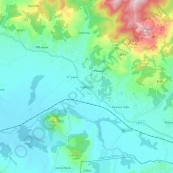
Name: Topografische Karte Kalesija, Höhe, Relief.
Durchschnittliche Höhe: 327 m
Minimale Höhe: 227 m
Maximale Höhe: 705 m
Spenden
Rüste dich für dein nächstes Abenteuer:
Als Amazon-Partner verdient diese Website an qualifizierten Käufen, ohne zusätzliche Kosten für Sie.
Andere topografische Karten
Klicken Sie auf eine Karte, um ihre Topografie, ihre Höhe und ihr Relief anzuzeigen.
Tuzla Canton
Bosnia and Herzegovina > Federation of Bosnia and Herzegovina
Durchschnittliche Höhe: 413 m
Zenica
Bosnia and Herzegovina > Federation of Bosnia and Herzegovina > City of Zenica
The city is geographically located in the heart of Bosnia. The settled area is 43.01 km2 (16.61 mi2) and of the city proper covers 558.5 km2 (215.6 mi2). Elevation is 310–350 m (1,017–1,148 ft). The rivers Bosna, Lašva, Babina, and Kočeva flow through the settlement. A moderate continental climate…
Durchschnittliche Höhe: 555 m
Mostar
Bosnia and Herzegovina > Federation of Bosnia and Herzegovina > City of Mostar
Durchschnittliche Höhe: 221 m
Spenden
Rüste dich für dein nächstes Abenteuer:
Als Amazon-Partner verdient diese Website an qualifizierten Käufen, ohne zusätzliche Kosten für Sie.
Pivnice
Bosnia and Herzegovina > Federation of Bosnia and Herzegovina > City of Cazin > Pivnice
Durchschnittliche Höhe: 379 m
Svrake
Bosnia and Herzegovina > Federation of Bosnia and Herzegovina > Svrake
Durchschnittliche Höhe: 639 m
Bihać
Bosnia and Herzegovina > Federation of Bosnia and Herzegovina > City of Bihać
Durchschnittliche Höhe: 368 m
Spenden
Rüste dich für dein nächstes Abenteuer:
Als Amazon-Partner verdient diese Website an qualifizierten Käufen, ohne zusätzliche Kosten für Sie.
Bjelašnica
Bosnia and Herzegovina > Federation of Bosnia and Herzegovina > City of Istočno Sarajevo
Bjelašnica (Serbian Cyrillic: Бјелашница, pronounced [bjělaːʃnit͡sa]) is a mountain in the Dinaric Alps in central Bosnia and Herzegovina. It is to the southwest of Sarajevo, bordering Mount Igman. Bjelašnica's tallest peak, by which the mountain group got its name, rises to an elevation of…
Durchschnittliche Höhe: 1.097 m
Rujnica
Bosnia and Herzegovina > Federation of Bosnia and Herzegovina > City of Cazin > Rujnica
Durchschnittliche Höhe: 303 m
Town of Konjic
Bosnia and Herzegovina > Federation of Bosnia and Herzegovina
Durchschnittliche Höhe: 993 m
Dinara
Bosnia and Herzegovina > Federation of Bosnia and Herzegovina > City of Livno
Durchschnittliche Höhe: 952 m
Spenden
Rüste dich für dein nächstes Abenteuer:
Als Amazon-Partner verdient diese Website an qualifizierten Käufen, ohne zusätzliche Kosten für Sie.
Town of Konjic
Bosnia and Herzegovina > Federation of Bosnia and Herzegovina
Durchschnittliche Höhe: 993 m
Čvrsnica
Bosnia and Herzegovina > Federation of Bosnia and Herzegovina
Durchschnittliche Höhe: 1.365 m
Sana
Bosnia and Herzegovina > Federation of Bosnia and Herzegovina
After 72 km and the altitude difference of 262.52 m, the Sana then passes through Sanski Most and combines with two significant tributary rivers, the Zdena and the Bliha river, both from the left, as well as the smaller Majdanuša from the left. From here it runs toward the town of Prijedor, where its middle…
Durchschnittliche Höhe: 570 m
Spenden
Rüste dich für dein nächstes Abenteuer:
Als Amazon-Partner verdient diese Website an qualifizierten Käufen, ohne zusätzliche Kosten für Sie.
Tržac
Bosnia and Herzegovina > Federation of Bosnia and Herzegovina > City of Cazin > Tržac
Durchschnittliche Höhe: 281 m
Bihać
Bosnia and Herzegovina > Federation of Bosnia and Herzegovina > City of Bihać
Durchschnittliche Höhe: 368 m
Spenden
Rüste dich für dein nächstes Abenteuer:
Als Amazon-Partner verdient diese Website an qualifizierten Käufen, ohne zusätzliche Kosten für Sie.
Čvrsnica
Bosnia and Herzegovina > Federation of Bosnia and Herzegovina
Durchschnittliche Höhe: 1.365 m
Neretva
Bosnia and Herzegovina > Federation of Bosnia and Herzegovina
Its source and headwaters gorge are situated deep in the Dinaric Alps at the base of the Zelengora and Lebršnik mountains, specifically under the Gredelj saddle. The river source is at 1,227 meters above sea level and consists of five small and distinct wellsprings. On its 90 kilometers course through the…
Durchschnittliche Höhe: 786 m
Sarajevo
Bosnia and Herzegovina > Federation of Bosnia and Herzegovina > City of Sarajevo
Durchschnittliche Höhe: 817 m
Mostar
Bosnia and Herzegovina > Federation of Bosnia and Herzegovina > City of Mostar
Durchschnittliche Höhe: 221 m
Spenden
Rüste dich für dein nächstes Abenteuer:
Als Amazon-Partner verdient diese Website an qualifizierten Käufen, ohne zusätzliche Kosten für Sie.
Igman
Bosnia and Herzegovina > Federation of Bosnia and Herzegovina > City of Istočno Sarajevo
Igman (Serbian Cyrillic: Игман, pronounced [îɡman]) is a mountain plateau in central Bosnia and Herzegovina. Geologically, Igman is part of the Dinaric Alps and formed largely of secondary and tertiary sedimentary rock, mostly Limestone. It is located southwest of Sarajevo, bordering the Bjelašnica…
Durchschnittliche Höhe: 895 m
Dinara
Bosnia and Herzegovina > Federation of Bosnia and Herzegovina > City of Livno
Durchschnittliche Höhe: 952 m
Bihać
Bosnia and Herzegovina > Federation of Bosnia and Herzegovina > City of Bihać
Durchschnittliche Höhe: 368 m
Spenden
Rüste dich für dein nächstes Abenteuer:
Als Amazon-Partner verdient diese Website an qualifizierten Käufen, ohne zusätzliche Kosten für Sie.
Ključ Municipality
Bosnia and Herzegovina > Federation of Bosnia and Herzegovina
Durchschnittliche Höhe: 604 m
Semizovac
Bosnia and Herzegovina > Federation of Bosnia and Herzegovina > Semizovac
Durchschnittliche Höhe: 579 m
Poprati
Bosnia and Herzegovina > Federation of Bosnia and Herzegovina > Town of Stolac
Durchschnittliche Höhe: 142 m
Spenden
Rüste dich für dein nächstes Abenteuer:
Als Amazon-Partner verdient diese Website an qualifizierten Käufen, ohne zusätzliche Kosten für Sie.
City of Mostar
Bosnia and Herzegovina > Federation of Bosnia and Herzegovina
Durchschnittliche Höhe: 783 m
Bjelašnica
Bosnia and Herzegovina > Federation of Bosnia and Herzegovina > City of Istočno Sarajevo
Durchschnittliche Höhe: 1.098 m
Bjelašnica
Bosnia and Herzegovina > Federation of Bosnia and Herzegovina > City of Istočno Sarajevo
Durchschnittliche Höhe: 1.098 m
Sarajevo
Bosnia and Herzegovina > Federation of Bosnia and Herzegovina > City of Sarajevo
Durchschnittliche Höhe: 750 m
Spenden
Rüste dich für dein nächstes Abenteuer:
Als Amazon-Partner verdient diese Website an qualifizierten Käufen, ohne zusätzliche Kosten für Sie.
Zaljut
Bosnia and Herzegovina > Federation of Bosnia and Herzegovina > Zaljut
Durchschnittliche Höhe: 897 m
Centar Municipality
Bosnia and Herzegovina > Federation of Bosnia and Herzegovina > City of Sarajevo
Durchschnittliche Höhe: 857 m
Sarajevo
Bosnia and Herzegovina > Federation of Bosnia and Herzegovina > City of Sarajevo
Durchschnittliche Höhe: 750 m
Spenden
Rüste dich für dein nächstes Abenteuer:
Als Amazon-Partner verdient diese Website an qualifizierten Käufen, ohne zusätzliche Kosten für Sie.
Bihać
Bosnia and Herzegovina > Federation of Bosnia and Herzegovina > City of Bihać
Durchschnittliche Höhe: 368 m
Sarajevo
Bosnia and Herzegovina > Federation of Bosnia and Herzegovina > City of Sarajevo
Durchschnittliche Höhe: 750 m
Sarajevo
Bosnia and Herzegovina > Federation of Bosnia and Herzegovina > City of Sarajevo
Durchschnittliche Höhe: 750 m
Una
Bosnia and Herzegovina > Federation of Bosnia and Herzegovina
The source of the Una river is located near the Croatian village of Donja Suvaja and consists of multiple smaller springs. The largest spring by discharge is a large karst spring at an elevation of 396 m (1,299 ft) above sea level, called Vrelo Une, and is considered to be the main spring of the river. The…
Durchschnittliche Höhe: 499 m
Spenden
Rüste dich für dein nächstes Abenteuer:
Als Amazon-Partner verdient diese Website an qualifizierten Käufen, ohne zusätzliche Kosten für Sie.
Igman
Bosnia and Herzegovina > Federation of Bosnia and Herzegovina > City of Istočno Sarajevo
Igman (Serbian Cyrillic: Игман, pronounced [îɡman]) is a mountain plateau in central Bosnia and Herzegovina. Geologically, Igman is part of the Dinaric Alps and formed largely of secondary and tertiary sedimentary rock, mostly Limestone. It is located southwest of Sarajevo, bordering the Bjelašnica…
Durchschnittliche Höhe: 895 m
Town of Konjic
Bosnia and Herzegovina > Federation of Bosnia and Herzegovina
Durchschnittliche Höhe: 993 m
Sarajevo
Bosnia and Herzegovina > Federation of Bosnia and Herzegovina > City of Sarajevo
Durchschnittliche Höhe: 750 m
Spenden
Rüste dich für dein nächstes Abenteuer:
Als Amazon-Partner verdient diese Website an qualifizierten Käufen, ohne zusätzliche Kosten für Sie.
Bihać
Bosnia and Herzegovina > Federation of Bosnia and Herzegovina > City of Bihać
Durchschnittliche Höhe: 368 m
Sarajevo
Bosnia and Herzegovina > Federation of Bosnia and Herzegovina > City of Sarajevo
Durchschnittliche Höhe: 750 m
Mostar
Bosnia and Herzegovina > Federation of Bosnia and Herzegovina > City of Mostar
Durchschnittliche Höhe: 221 m
Spenden
Rüste dich für dein nächstes Abenteuer:
Als Amazon-Partner verdient diese Website an qualifizierten Käufen, ohne zusätzliche Kosten für Sie.
Sarajevo
Bosnia and Herzegovina > Federation of Bosnia and Herzegovina > City of Sarajevo
Durchschnittliche Höhe: 750 m
Mostar
Bosnia and Herzegovina > Federation of Bosnia and Herzegovina > City of Mostar
Durchschnittliche Höhe: 221 m
Bihać
Bosnia and Herzegovina > Federation of Bosnia and Herzegovina > City of Bihać
Durchschnittliche Höhe: 368 m
Town of Konjic
Bosnia and Herzegovina > Federation of Bosnia and Herzegovina
Durchschnittliche Höhe: 993 m
Spenden
Rüste dich für dein nächstes Abenteuer:
Als Amazon-Partner verdient diese Website an qualifizierten Käufen, ohne zusätzliche Kosten für Sie.