
Topografische Karte The Block
Interaktive Karte
Klicken Sie auf die Karte, um die Höhe anzuzeigen.
Über diese Karte
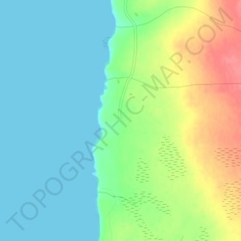
Name: Topografische Karte The Block, Höhe, Relief.
Ort: The Block, Newfoundland, Newfoundland en Labrador, Canada (47.78844 -59.33841 47.80844 -59.31841)
Durchschnittliche Höhe: 23 m
Minimale Höhe: 0 m
Maximale Höhe: 68 m
Andere topografische Karten
Klicken Sie auf eine Karte, um ihre Topografie, ihre Höhe und ihr Relief anzuzeigen.
Newfoundland
Canada > Newfoundland en Labrador
Newfoundland, Newfoundland en Labrador, Canada
Durchschnittliche Höhe: 87 m
Port au Port Peninsula
Canada > Newfoundland en Labrador > Lourdes
Port au Port Peninsula, Highway 463, Lourdes, Newfoundland en Labrador, Canada
Durchschnittliche Höhe: 142 m
Corner Brook
Canada > Newfoundland en Labrador > Corner Brook
Corner Brook, Newfoundland, Newfoundland en Labrador, Canada
Durchschnittliche Höhe: 236 m
St. John's
Canada > Newfoundland en Labrador > St. John's
St. John's, Newfoundland, Newfoundland en Labrador, A1C 2G4, Canada
Durchschnittliche Höhe: 66 m
Norris Point
Canada > Newfoundland en Labrador > Norris Point
Norris Point, Newfoundland en Labrador, A0K 3V0, Canada
Durchschnittliche Höhe: 86 m
Western Brook Pond
Canada > Newfoundland en Labrador
Western Brook Pond, Snug Harbour to North Rim, Newfoundland en Labrador, Canada
Durchschnittliche Höhe: 337 m