
Topografische Karte Silao
Interaktive Karte
Klicken Sie auf die Karte, um die Höhe anzuzeigen.
Über diese Karte
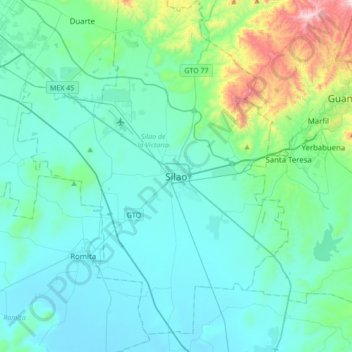
Name: Topografische Karte Silao, Höhe, Relief.
Durchschnittliche Höhe: 1.877 m
Minimale Höhe: 1.735 m
Maximale Höhe: 2.705 m
The territory of Silao is almost planar formed in by the Bajío, between its few important elevations, one can find the 'Cerro del Cubilete' whose altitude is 2,570 meters above sea level and is considered the geographic center of the country.