
Spenden
Rüste dich für dein nächstes Abenteuer:
Als Amazon-Partner verdient diese Website an qualifizierten Käufen, ohne zusätzliche Kosten für Sie.
Topografische Karte Glenridding Dodd
Klicken Sie auf die Karte, um die Höhe anzuzeigen.
Spenden
Rüste dich für dein nächstes Abenteuer:
Als Amazon-Partner verdient diese Website an qualifizierten Käufen, ohne zusätzliche Kosten für Sie.
Glenridding Dodd
Glenridding Dodd (the rounded hill above Glenridding) is a small fell in the English Lake District, at the end of a ridge descending from the Helvellyn range in the Eastern Fells. It stands above the village of Glenridding and on the western shore of Ullswater. Although small and not of great elevation, its top is a fine viewpoint for Ullswater and for the fells clustered round the valleys above Patterdale.
Spenden
Rüste dich für dein nächstes Abenteuer:
Als Amazon-Partner verdient diese Website an qualifizierten Käufen, ohne zusätzliche Kosten für Sie.
Über diese Karte
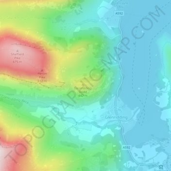
Name: Topografische Karte Glenridding Dodd, Höhe, Relief.
Durchschnittliche Höhe: 298 m
Minimale Höhe: 143 m
Maximale Höhe: 698 m
Spenden
Rüste dich für dein nächstes Abenteuer:
Als Amazon-Partner verdient diese Website an qualifizierten Käufen, ohne zusätzliche Kosten für Sie.