
Topografische Karte Tiniguiban
Interaktive Karte
Klicken Sie auf die Karte, um die Höhe anzuzeigen.
Über diese Karte
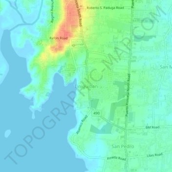
Name: Topografische Karte Tiniguiban, Höhe, Relief.
Ort: Tiniguiban, Puerto Princesa, Mimaropa, Philippines (9.75437 118.71796 9.79437 118.75796)
Durchschnittliche Höhe: 11 m
Minimale Höhe: -3 m
Maximale Höhe: 47 m
Andere topografische Karten
Klicken Sie auf eine Karte, um ihre Topografie, ihre Höhe und ihr Relief anzuzeigen.
Maningning
Maningning, Puerto Princesa, Mimaropa, Philippines
Durchschnittliche Höhe: 8 m
Tagburos
Tagburos, Puerto Princesa, Mimaropa, Philippines
Durchschnittliche Höhe: 16 m
Santa Cruz
Santa Cruz, Puerto Princesa, Mimaropa, 5300, Philippines
Durchschnittliche Höhe: 37 m
Cabayugan
Cabayugan, Puerto Princesa, Mimaropa, Philippines
Durchschnittliche Höhe: 127 m
New Panggangan
Philippines > Puerto Princesa > New Panggangan
New Panggangan, Puerto Princesa, Mimaropa, Philippines
Durchschnittliche Höhe: 61 m
Luzviminda
Luzviminda, Puerto Princesa, Mimaropa, Philippines
Durchschnittliche Höhe: 33 m
Matahimik
Philippines > Puerto Princesa > Matahimik
Matahimik, Puerto Princesa, Mimaropa, 5300, Philippines
Durchschnittliche Höhe: 2 m