
Spenden
Rüste dich für dein nächstes Abenteuer:
Als Amazon-Partner verdient diese Website an qualifizierten Käufen, ohne zusätzliche Kosten für Sie.
Topografische Karte Needham
Klicken Sie auf die Karte, um die Höhe anzuzeigen.
Spenden
Rüste dich für dein nächstes Abenteuer:
Als Amazon-Partner verdient diese Website an qualifizierten Käufen, ohne zusätzliche Kosten für Sie.
Needham
Needham's area is roughly in the shape of an acute, northward-pointing triangle. The Charles River forms nearly all of the southern and northeastern boundaries, the town line with Wellesley forming the third, northwestern one. In addition to Wellesley on the northwest, Needham borders Newton and the West Roxbury section of Boston on the northeast, and Dover, Westwood, and Dedham on the south. The majority of Cutler Park is in Needham and is located along the Charles River and the border with Newton and West Roxbury. Elevations in Needham range from 85 feet above sea level at Rosemary Meadows to 180 feet at Needham Square and 300 feet at Bird's Hill.
Spenden
Rüste dich für dein nächstes Abenteuer:
Als Amazon-Partner verdient diese Website an qualifizierten Käufen, ohne zusätzliche Kosten für Sie.
Über diese Karte
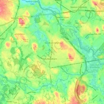
Name: Topografische Karte Needham, Höhe, Relief.
Ort: Needham, Norfolk County, Massachusetts, United States (42.25484 -71.30127 42.31652 -71.18820)
Durchschnittliche Höhe: 46 m
Minimale Höhe: 11 m
Maximale Höhe: 98 m
Spenden
Rüste dich für dein nächstes Abenteuer:
Als Amazon-Partner verdient diese Website an qualifizierten Käufen, ohne zusätzliche Kosten für Sie.
Andere topografische Karten
Klicken Sie auf eine Karte, um ihre Topografie, ihre Höhe und ihr Relief anzuzeigen.
East Braintree
United States > Massachusetts > Norfolk County > Braintree
Durchschnittliche Höhe: 22 m
Charles River Village
United States > Massachusetts > Norfolk County > Needham
Durchschnittliche Höhe: 49 m
Weymouth Landing
United States > Massachusetts > Norfolk County > Weymouth
Durchschnittliche Höhe: 21 m
Spenden
Rüste dich für dein nächstes Abenteuer:
Als Amazon-Partner verdient diese Website an qualifizierten Käufen, ohne zusätzliche Kosten für Sie.
Spenden
Rüste dich für dein nächstes Abenteuer:
Als Amazon-Partner verdient diese Website an qualifizierten Käufen, ohne zusätzliche Kosten für Sie.
Weymouth Woods
United States > Massachusetts > Norfolk County > Weymouth > South Weymouth > Pine Grove
Durchschnittliche Höhe: 49 m
Spenden
Rüste dich für dein nächstes Abenteuer:
Als Amazon-Partner verdient diese Website an qualifizierten Käufen, ohne zusätzliche Kosten für Sie.
Crooks Corner
United States > Massachusetts > Norfolk County > Bellingham
Durchschnittliche Höhe: 68 m
Crooks Corner
United States > Massachusetts > Norfolk County > Bellingham
Durchschnittliche Höhe: 68 m
Spenden
Rüste dich für dein nächstes Abenteuer:
Als Amazon-Partner verdient diese Website an qualifizierten Käufen, ohne zusätzliche Kosten für Sie.
North Foxboro
United States > Massachusetts > Norfolk County > Foxborough
Durchschnittliche Höhe: 90 m
Spenden
Rüste dich für dein nächstes Abenteuer:
Als Amazon-Partner verdient diese Website an qualifizierten Käufen, ohne zusätzliche Kosten für Sie.
South Foxboro
United States > Massachusetts > Norfolk County > Foxborough
Durchschnittliche Höhe: 63 m
Spenden
Rüste dich für dein nächstes Abenteuer:
Als Amazon-Partner verdient diese Website an qualifizierten Käufen, ohne zusätzliche Kosten für Sie.
Spenden
Rüste dich für dein nächstes Abenteuer:
Als Amazon-Partner verdient diese Website an qualifizierten Käufen, ohne zusätzliche Kosten für Sie.
Lake Massapoag
United States > Massachusetts > Norfolk County > Sharon
Because of the lake and the fact that Sharon is at a slightly higher elevation than the surrounding towns, and because it is located on the main rail line going south from Boston, the shores of the lake developed into a minor summer resort with several large hotels, summer camps and cottage colonies. Temple…
Durchschnittliche Höhe: 84 m
Clark Pond Reservoir
United States > Massachusetts > Norfolk County > Walpole
Durchschnittliche Höhe: 65 m
Spenden
Rüste dich für dein nächstes Abenteuer:
Als Amazon-Partner verdient diese Website an qualifizierten Käufen, ohne zusätzliche Kosten für Sie.
Needham Junction
United States > Massachusetts > Norfolk County > Needham
Durchschnittliche Höhe: 46 m
Spenden
Rüste dich für dein nächstes Abenteuer:
Als Amazon-Partner verdient diese Website an qualifizierten Käufen, ohne zusätzliche Kosten für Sie.
Medfield Junction
United States > Massachusetts > Norfolk County > Medfield
Durchschnittliche Höhe: 49 m
Spenden
Rüste dich für dein nächstes Abenteuer:
Als Amazon-Partner verdient diese Website an qualifizierten Käufen, ohne zusätzliche Kosten für Sie.
Wrentham
United States > Massachusetts > Norfolk County > Wrentham > Wrentham
Durchschnittliche Höhe: 79 m
East Braintree
United States > Massachusetts > Norfolk County > Braintree
Durchschnittliche Höhe: 22 m
Wellesley Farms
United States > Massachusetts > Norfolk County > Wellesley > Wellesley Farms
Durchschnittliche Höhe: 48 m
Spenden
Rüste dich für dein nächstes Abenteuer:
Als Amazon-Partner verdient diese Website an qualifizierten Käufen, ohne zusätzliche Kosten für Sie.
Ashcroft
United States > Massachusetts > Norfolk County > Dedham > Ashcroft
Durchschnittliche Höhe: 30 m
Single Tree Hill
United States > Massachusetts > Norfolk County > Brookline
Durchschnittliche Höhe: 58 m
Crownridge Estates
United States > Massachusetts > Norfolk County > Medfield
Durchschnittliche Höhe: 47 m
Saint Marks Park
United States > Massachusetts > Norfolk County > Brookline
Durchschnittliche Höhe: 25 m
Spenden
Rüste dich für dein nächstes Abenteuer:
Als Amazon-Partner verdient diese Website an qualifizierten Käufen, ohne zusätzliche Kosten für Sie.