
Topografische Karte Blairgowrie and Rattray
Interaktive Karte
Klicken Sie auf die Karte, um die Höhe anzuzeigen.
Über diese Karte
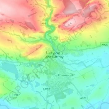
Name: Topografische Karte Blairgowrie and Rattray, Höhe, Relief.
Durchschnittliche Höhe: 121 m
Minimale Höhe: 31 m
Maximale Höhe: 295 m
Andere topografische Karten
Klicken Sie auf eine Karte, um ihre Topografie, ihre Höhe und ihr Relief anzuzeigen.
Moulin
Royaume-Uni > Écosse > Perth and Kinross
Moulin, Perth and Kinross, Écosse, PH16 5EW, Royaume-Uni
Durchschnittliche Höhe: 243 m
Dunning
Royaume-Uni > Écosse > Perth and Kinross
Dunning, Perth and Kinross, Écosse, PH2 0RT, Royaume-Uni
Durchschnittliche Höhe: 91 m
Crieff
Royaume-Uni > Écosse > Perth and Kinross
Crieff, Perth and Kinross, Écosse, PH7 3BS, Royaume-Uni
Durchschnittliche Höhe: 115 m
Luncarty
Royaume-Uni > Écosse > Perth and Kinross
Luncarty, Perth and Kinross, Écosse, PH1 3YU, Royaume-Uni
Durchschnittliche Höhe: 37 m
Scotlandwell
Royaume-Uni > Écosse > Perth and Kinross
Scotlandwell, Perth and Kinross, Écosse, KY13 9NA, Royaume-Uni
Durchschnittliche Höhe: 168 m