
Topografische Karte Lac Utah
Interaktive Karte
Klicken Sie auf die Karte, um die Höhe anzuzeigen.
Über diese Karte
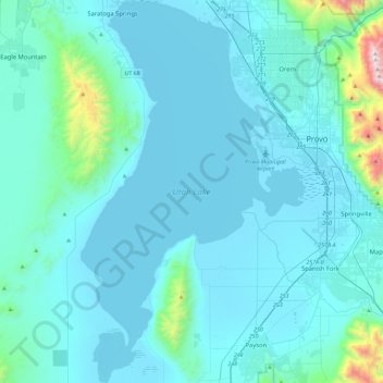
Name: Topografische Karte Lac Utah, Höhe, Relief.
Durchschnittliche Höhe: 1.512 m
Minimale Höhe: 1.364 m
Maximale Höhe: 3.304 m
Andere topografische Karten
Klicken Sie auf eine Karte, um ihre Topografie, ihre Höhe und ihr Relief anzuzeigen.
Moab
États-Unis d'Amérique > Utah > Grand County
Moab, Grand County, Utah, 84532, États-Unis d'Amérique
Durchschnittliche Höhe: 1.357 m
Bryce Canyon National Park
États-Unis d'Amérique > Utah > Garfield County
Bryce Canyon National Park, Garfield County, Utah, États-Unis d'Amérique
Durchschnittliche Höhe: 2.259 m
Torrey
États-Unis d'Amérique > Utah > Torrey
Torrey, Wayne County, Utah, États-Unis d'Amérique
Durchschnittliche Höhe: 2.090 m
Price
États-Unis d'Amérique > Utah > Price
Price, Carbon County, Utah, 84501, États-Unis d'Amérique
Durchschnittliche Höhe: 1.711 m
Salt Lake County
Salt Lake County, Utah, États-Unis d'Amérique
Durchschnittliche Höhe: 1.811 m
Bryce Canyon City
États-Unis d'Amérique > Utah > Bryce Canyon City
Bryce Canyon City, Garfield County, Utah, 640001, États-Unis d'Amérique
Durchschnittliche Höhe: 2.333 m
Arches National Park
Arches National Park, Arches Hiking, Grand County, Utah, États-Unis d'Amérique
Durchschnittliche Höhe: 1.476 m
St. George
États-Unis d'Amérique > Utah > Washington County > St. George
St. George, Washington County, Utah, États-Unis d'Amérique
Durchschnittliche Höhe: 929 m
Zion National Park
Zion National Park, West Rim Trail, Washington County, Utah, États-Unis d'Amérique
Durchschnittliche Höhe: 1.877 m