
Topografische Karte Prospect
Interaktive Karte
Klicken Sie auf die Karte, um die Höhe anzuzeigen.
Über diese Karte
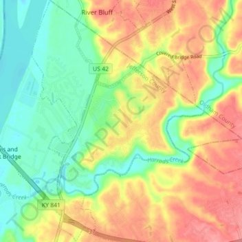
Name: Topografische Karte Prospect, Höhe, Relief.
Ort: Prospect, Jefferson County, Kentucky, United States (38.31846 -85.63063 38.37342 -85.58055)
Durchschnittliche Höhe: 166 m
Minimale Höhe: 128 m
Maximale Höhe: 208 m
Andere topografische Karten
Klicken Sie auf eine Karte, um ihre Topografie, ihre Höhe und ihr Relief anzuzeigen.
Kenwood
United States > Kentucky > Jefferson County > Louisville
Kenwood, Louisville, Jefferson County, Kentucky, 40214, United States
Durchschnittliche Höhe: 153 m
Glenview
United States > Kentucky > Jefferson County
Glenview, Jefferson County, Kentucky, 40025, United States
Durchschnittliche Höhe: 155 m
Oakdale
United States > Kentucky > Jefferson County > Louisville > Oakdale
Oakdale, Louisville, Jefferson County, Kentucky, 40215, United States
Durchschnittliche Höhe: 143 m
Coldstream
United States > Kentucky > Jefferson County
Coldstream, Jefferson County, Kentucky, United States
Durchschnittliche Höhe: 219 m
Riverwood
United States > Kentucky > Jefferson County
Riverwood, Jefferson County, Kentucky, United States
Durchschnittliche Höhe: 162 m