
Topografische Karte Eagle Nest
Interaktive Karte
Klicken Sie auf die Karte, um die Höhe anzuzeigen.
Über diese Karte
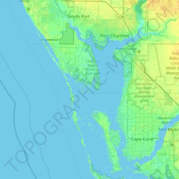
Name: Topografische Karte Eagle Nest, Höhe, Relief.
Ort: Eagle Nest, Charlotte County, Florida, United States (26.46229 -82.51148 27.10229 -81.87148)
Durchschnittliche Höhe: 3 m
Minimale Höhe: -1 m
Maximale Höhe: 16 m
Andere topografische Karten
Klicken Sie auf eine Karte, um ihre Topografie, ihre Höhe und ihr Relief anzuzeigen.
Rotonda West
United States > Florida > Charlotte County
Rotonda West, Charlotte County, Florida, 33947, United States
Durchschnittliche Höhe: 3 m
Punta Gorda
United States > Florida > Charlotte County
Punta Gorda, Charlotte County, Florida, United States
Durchschnittliche Höhe: 3 m
Port Charlotte
United States > Florida > Charlotte County
Port Charlotte, Charlotte County, Florida, United States
Durchschnittliche Höhe: 4 m
Harbour Heights
United States > Florida > Charlotte County > Deep Creek
Harbour Heights, Deep Creek, Charlotte County, Florida, 33983, United States
Durchschnittliche Höhe: 4 m