
Topografische Karte Antequera
Interaktive Karte
Klicken Sie auf die Karte, um die Höhe anzuzeigen.
Über diese Karte
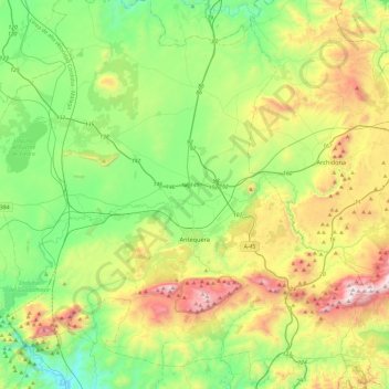
Name: Topografische Karte Antequera, Höhe, Relief.
Ort: Antequera, Malaga, Andalusia, Spain (36.89369 -4.82779 37.23108 -4.34693)
Durchschnittliche Höhe: 570 m
Minimale Höhe: 141 m
Maximale Höhe: 1.429 m
In 2011, Antequera had a population of 41,854. It covers an area of 749.34 km2 with a population density of 55.85 inhabitants/km2, and is situated at an altitude of 575 meters. Antequera is the most populous city in the interior of the province and the largest in area. It is the twenty-second largest in Spain. The city is located 45 km from Málaga and 115 km from Córdoba. The cities are connected by a high-speed train and the A-45 motorway. Antequera is 160 km from Seville and 102 km from Granada, which is connected by motorway A-92 and will be connected by the high-speed Transverse Axis Rail in the near future.
Andere topografische Karten
Klicken Sie auf eine Karte, um ihre Topografie, ihre Höhe und ihr Relief anzuzeigen.
Mataliebres
Spain > Andalusia > Antequera > Mollina
Mataliebres, Mollina, Antequera, Malaga, Andalusia, 29530, Spain
Durchschnittliche Höhe: 554 m
Casabermeja
Casabermeja, Antequera, Malaga, Andalusia, 29160, Spain
Durchschnittliche Höhe: 595 m