
Spenden
Rüste dich für dein nächstes Abenteuer:
Als Amazon-Partner verdient diese Website an qualifizierten Käufen, ohne zusätzliche Kosten für Sie.
Topografische Karte Don Carlos
Klicken Sie auf die Karte, um die Höhe anzuzeigen.
Spenden
Rüste dich für dein nächstes Abenteuer:
Als Amazon-Partner verdient diese Website an qualifizierten Käufen, ohne zusätzliche Kosten für Sie.
Don Carlos
The terrain of the municipality of Don Carlos is generally flat except the mountain range on the eastern part of the municipality. The highest elevation is 700 metres (2,300 ft) above sea level and the lowest elevation is 300 metres (980 ft) below sea level.
Spenden
Rüste dich für dein nächstes Abenteuer:
Als Amazon-Partner verdient diese Website an qualifizierten Käufen, ohne zusätzliche Kosten für Sie.
Über diese Karte
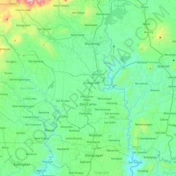
Name: Topografische Karte Don Carlos, Höhe, Relief.
Ort: Don Carlos, Bukidnon, Northern Mindanao, Philippines (7.62837 124.81783 7.77481 125.05472)
Durchschnittliche Höhe: 330 m
Minimale Höhe: 106 m
Maximale Höhe: 1.138 m
Spenden
Rüste dich für dein nächstes Abenteuer:
Als Amazon-Partner verdient diese Website an qualifizierten Käufen, ohne zusätzliche Kosten für Sie.
Andere topografische Karten
Klicken Sie auf eine Karte, um ihre Topografie, ihre Höhe und ihr Relief anzuzeigen.