
Spenden
Rüste dich für dein nächstes Abenteuer:
Als Amazon-Partner verdient diese Website an qualifizierten Käufen, ohne zusätzliche Kosten für Sie.
Topografische Karte Upper Seneca Crest
Klicken Sie auf die Karte, um die Höhe anzuzeigen.
Spenden
Rüste dich für dein nächstes Abenteuer:
Als Amazon-Partner verdient diese Website an qualifizierten Käufen, ohne zusätzliche Kosten für Sie.
Über diese Karte
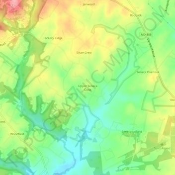
Name: Topografische Karte Upper Seneca Crest, Höhe, Relief.
Durchschnittliche Höhe: 177 m
Minimale Höhe: 130 m
Maximale Höhe: 238 m
Spenden
Rüste dich für dein nächstes Abenteuer:
Als Amazon-Partner verdient diese Website an qualifizierten Käufen, ohne zusätzliche Kosten für Sie.
Andere topografische Karten
Klicken Sie auf eine Karte, um ihre Topografie, ihre Höhe und ihr Relief anzuzeigen.
Spenden
Rüste dich für dein nächstes Abenteuer:
Als Amazon-Partner verdient diese Website an qualifizierten Käufen, ohne zusätzliche Kosten für Sie.
Spenden
Rüste dich für dein nächstes Abenteuer:
Als Amazon-Partner verdient diese Website an qualifizierten Käufen, ohne zusätzliche Kosten für Sie.
Darnestown
United States > Maryland > Montgomery County
In the 2000 census, the Census Bureau created a new Census-designated place (CDP) called Darnestown. A Darnestown CDP was also used in the 2010 census. The Darnestown CDP has 16.39 square miles (42.4 km2) of land, which is smaller than the old Darnestown MCD. The CDP uses the Muddy Branch, Turkey Foot Road,…
Durchschnittliche Höhe: 97 m
Spenden
Rüste dich für dein nächstes Abenteuer:
Als Amazon-Partner verdient diese Website an qualifizierten Käufen, ohne zusätzliche Kosten für Sie.
Travilah
United States > Maryland > Montgomery County > Travilah
The United States Geological Survey lists six features in Montgomery County with Travilah in all or part of their name. The Travilah Census Designated Place has an ID of 2390400 and an elevation of 233 feet. It has a latitude of 390325N and a longitude of 0771445W—a location of 39°3′25″N…
Durchschnittliche Höhe: 96 m
Spenden
Rüste dich für dein nächstes Abenteuer:
Als Amazon-Partner verdient diese Website an qualifizierten Käufen, ohne zusätzliche Kosten für Sie.
Burtonsville
United States > Maryland > Montgomery County > Burtonsville
Durchschnittliche Höhe: 119 m
North Kensington
United States > Maryland > Montgomery County > North Kensington
Durchschnittliche Höhe: 103 m
Spencerville
United States > Maryland > Montgomery County > Spencerville
Durchschnittliche Höhe: 148 m
Montgomery Village
United States > Maryland > Montgomery County > Montgomery Village
Durchschnittliche Höhe: 132 m
Spenden
Rüste dich für dein nächstes Abenteuer:
Als Amazon-Partner verdient diese Website an qualifizierten Käufen, ohne zusätzliche Kosten für Sie.