
Topografische Karte Babati
Interaktive Karte
Klicken Sie auf die Karte, um die Höhe anzuzeigen.
Über diese Karte
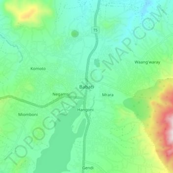
Name: Topografische Karte Babati, Höhe, Relief.
Durchschnittliche Höhe: 1.392 m
Minimale Höhe: 1.206 m
Maximale Höhe: 1.963 m
Babati town has developed from a mere village since Babati District was established in 1985. The new status boosted the town into rapid growth. The town is located at an altitude of 2,145 metres or 7,037 feet near the end of Tarangire National Park and the base of Lake Babati, nestling under Mount Kwaraha.
Andere topografische Karten
Klicken Sie auf eine Karte, um ihre Topografie, ihre Höhe und ihr Relief anzuzeigen.
Simanjiro
Simanjiro, Manyara Region, Northern Zone, Tanzania
Durchschnittliche Höhe: 1.111 m
Kwa Kuchinia
Kwa Kuchinia, Babati, Manyara Region, Northern Zone, Tanzania
Durchschnittliche Höhe: 1.004 m