
Topografische Karte Glenside
Interaktive Karte
Klicken Sie auf die Karte, um die Höhe anzuzeigen.
Über diese Karte
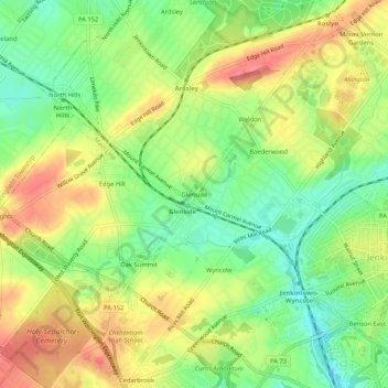
Name: Topografische Karte Glenside, Höhe, Relief.
Durchschnittliche Höhe: 94 m
Minimale Höhe: 58 m
Maximale Höhe: 133 m
Andere topografische Karten
Klicken Sie auf eine Karte, um ihre Topografie, ihre Höhe und ihr Relief anzuzeigen.
Roslyn
United States > Pennsylvania > Montgomery County > Abington Township
Roslyn, Abington Township, Montgomery County, Pennsylvania, 19001, United States
Durchschnittliche Höhe: 94 m
Rydal Park
United States > Pennsylvania > Montgomery County > Abington Township
Rydal Park, Abington Township, Montgomery County, Pennsylvania, 19046, United States
Durchschnittliche Höhe: 87 m
Mount Vernon Gardens
United States > Pennsylvania > Montgomery County > Abington Township
Mount Vernon Gardens, Abington Township, Montgomery County, Pennsylvania, 19001, United States
Durchschnittliche Höhe: 93 m
Meadowbrook
United States > Pennsylvania > Montgomery County > Abington Township
Meadowbrook, Abington Township, Montgomery County, Pennsylvania, 19006, United States
Durchschnittliche Höhe: 66 m
Hollywood
United States > Pennsylvania > Montgomery County > Abington Township
Hollywood, Abington Township, Montgomery County, Pennsylvania, 19046, United States
Durchschnittliche Höhe: 69 m