
Topografische Karte Cap La Ronde
Interaktive Karte
Klicken Sie auf die Karte, um die Höhe anzuzeigen.
Über diese Karte
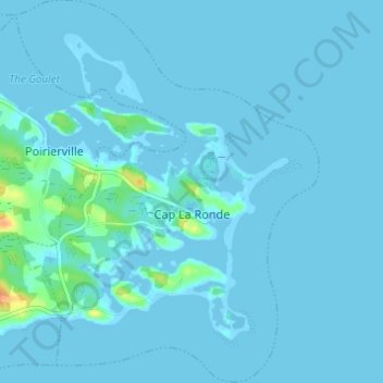
Name: Topografische Karte Cap La Ronde, Höhe, Relief.
Durchschnittliche Höhe: 2 m
Minimale Höhe: -5 m
Maximale Höhe: 35 m
Andere topografische Karten
Klicken Sie auf eine Karte, um ihre Topografie, ihre Höhe und ihr Relief anzuzeigen.
Battery Provincial Park
Canada > Nova Scotia > Municipality of the County of Richmond > St. Peter's
Battery Provincial Park, St. Peter's, Municipality of the County of Richmond, Richmond County, Nova Scotia, Canada
Durchschnittliche Höhe: 9 m
Louisdale
Canada > Nova Scotia > Municipality of the County of Richmond
Louisdale, Municipality of the County of Richmond, Richmond County, Nova Scotia, B0E 1V0, Canada
Durchschnittliche Höhe: 26 m
Potato Island
Canada > Nova Scotia > Municipality of the County of Richmond > Poirierville
Potato Island, Poirierville, Municipality of the County of Richmond, Richmond County, Nova Scotia, Canada
Durchschnittliche Höhe: 4 m
Thorn Creek
Canada > Nova Scotia > Municipality of the County of Richmond > Glasgow Point
Thorn Creek, Glasgow Point, Municipality of the County of Richmond, Richmond County, Nova Scotia, Canada
Durchschnittliche Höhe: 4 m
St. Peters Inlet
Canada > Nova Scotia > Municipality of the County of Richmond > Barra Head
St. Peters Inlet, Chapel Island 5, Barra Head, Municipality of the County of Richmond, Richmond County, Nova Scotia, Canada
Durchschnittliche Höhe: 17 m
Berry Island
Canada > Nova Scotia > Municipality of the County of Richmond > Martinique
Berry Island, Martinique, Municipality of the County of Richmond, Richmond County, Nova Scotia, B0E 1V0, Canada
Durchschnittliche Höhe: 41 m