
Topografische Karte Babia Góra / Babia hora
Interaktive Karte
Klicken Sie auf die Karte, um die Höhe anzuzeigen.
Über diese Karte
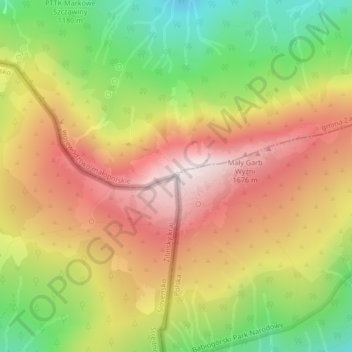
Name: Topografische Karte Babia Góra / Babia hora, Höhe, Relief.
Durchschnittliche Höhe: 1.395 m
Minimale Höhe: 1.039 m
Maximale Höhe: 1.719 m
Gentle from the south, steep from the north, Babia Góra is home to bear, lynx, wolf and other species; as well as alpine flora endemic at this altitude. The first attempts to protect the area were made in the 1930s. In 1933 the Nature Reserve of Babia Góra was established on the Polish side. Later, in 1954, the Babia Góra National Park (Babiogórski Park Narodowy) was established with an area of 17.04 km2. In 1976 it became one of the first Biosphere Reserves in the world. For a long time Babia Góra National Park was the smallest of the Polish national parks. In 1997 it was enlarged to 33.92 km2 and a buffer zone was created of 84.37 km2. Within the park, 10.62 km2 is under strict protection. There are calls for strengthening of cross-border cooperation with Slovakia to better protect the fragile environment of the mountain.
Andere topografische Karten
Klicken Sie auf eine Karte, um ihre Topografie, ihre Höhe und ihr Relief anzuzeigen.
Zawoja
Poland > Lesser Poland Voivodeship > Sucha County > Zawoja
Zawoja, gmina Zawoja, Sucha County, Lesser Poland Voivodeship, Poland
Durchschnittliche Höhe: 829 m