
Topografische Karte Monselice
Interaktive Karte
Klicken Sie auf die Karte, um die Höhe anzuzeigen.
Über diese Karte
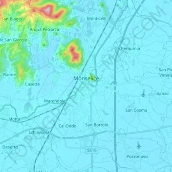
Name: Topografische Karte Monselice, Höhe, Relief.
Ort: Monselice, Padova, Veneto, 35043, Italy (45.18765 11.69656 45.28679 11.81688)
Durchschnittliche Höhe: 23 m
Minimale Höhe: -2 m
Maximale Höhe: 390 m
The modern town lies in a wide valley between the Montericco, elevation 312 metres (1,024 ft), and the Rocca, elevation 110 metres (360 ft), hills (part of the Euganean Hills).
Andere topografische Karten
Klicken Sie auf eine Karte, um ihre Topografie, ihre Höhe und ihr Relief anzuzeigen.
San Martino di Lupari
San Martino di Lupari, Padova, Veneto, Italy
Durchschnittliche Höhe: 41 m
Piombino Dese
Piombino Dese, Padova, Veneto, 35017, Italy
Durchschnittliche Höhe: 26 m
Piazzola sul Brenta
Italy > Veneto > Padova > Piazzola sul Brenta
Piazzola sul Brenta, Padova, Veneto, 35016, Italy
Durchschnittliche Höhe: 26 m
Abano Terme
Italy > Veneto > Padova > Abano Terme
Abano Terme, Padova, Veneto, 35031, Italy
Durchschnittliche Höhe: 14 m