
Topografische Karte Hudson
Interaktive Karte
Klicken Sie auf die Karte, um die Höhe anzuzeigen.
Über diese Karte
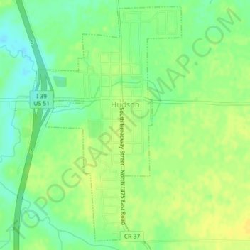
Name: Topografische Karte Hudson, Höhe, Relief.
Ort: Hudson, McLean County, Illinois, United States (40.59082 -89.00085 40.61647 -88.97929)
Durchschnittliche Höhe: 234 m
Minimale Höhe: 222 m
Maximale Höhe: 243 m
Andere topografische Karten
Klicken Sie auf eine Karte, um ihre Topografie, ihre Höhe und ihr Relief anzuzeigen.
Towanda
United States > Illinois > McLean County
Towanda, McLean County, Illinois, 61776, United States
Durchschnittliche Höhe: 239 m
Bloomington
United States > Illinois > McLean County
Bloomington, McLean County, Illinois, United States
Durchschnittliche Höhe: 246 m
Clarksville
United States > Illinois > McLean County
Clarksville, McLean County, Illinois, United States
Durchschnittliche Höhe: 224 m
Bellflower
United States > Illinois > McLean County
Bellflower, McLean County, Illinois, 61724, United States
Durchschnittliche Höhe: 235 m
Heyworth
United States > Illinois > McLean County > Heyworth
Heyworth, McLean County, Illinois, United States
Durchschnittliche Höhe: 227 m
Normal
United States > Illinois > McLean County
Normal, McLean County, Illinois, United States
Durchschnittliche Höhe: 249 m