
Topografische Karte Pistoia
Interaktive Karte
Klicken Sie auf die Karte, um die Höhe anzuzeigen.
Über diese Karte
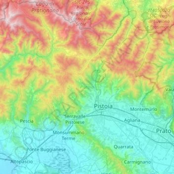
Name: Topografische Karte Pistoia, Höhe, Relief.
Ort: Pistoia, Tuscany, Italy (43.78810 10.62092 44.16018 11.07148)
Durchschnittliche Höhe: 530 m
Minimale Höhe: 4 m
Maximale Höhe: 1.932 m
Andere topografische Karten
Klicken Sie auf eine Karte, um ihre Topografie, ihre Höhe und ihr Relief anzuzeigen.
Principina Terra
Italy > Tuscany > Grosseto > Grosseto
Principina Terra, Grosseto, Tuscany, 58100, Italy
Durchschnittliche Höhe: 3 m
Monte Citerna
Italy > Tuscany > Metropolitan City of Florence > Barberino di Mugello
Monte Citerna, Barberino di Mugello, Metropolitan City of Florence, Tuscany, Italy
Durchschnittliche Höhe: 733 m
Le Strade
Italy > Tuscany > Monteverdi Marittimo
Le Strade, Monteverdi Marittimo, Pisa, Tuscany, Italy
Durchschnittliche Höhe: 231 m
Gaiole in Chianti
Italy > Tuscany > Gaiole in Chianti
Gaiole in Chianti, SI, Tuscany, 53013, Italy
Durchschnittliche Höhe: 433 m
Pontassieve
Italy > Tuscany > Pontassieve
Pontassieve, Metropolitan City of Florence, Tuscany, Italy
Durchschnittliche Höhe: 364 m
Castel del Piano
Italy > Tuscany > Castel del Piano
Castel del Piano, Unione dei Comuni Montani Amiata Grossetana, GR, Tuscany, 58033, Italy
Durchschnittliche Höhe: 561 m