
Topografische Karte Cetina
Interaktive Karte
Klicken Sie auf die Karte, um die Höhe anzuzeigen.
Cetina
Cetina is a municipality in the province of Zaragoza, Aragon. It is situated at an altitude of 666 metres (2,185 ft) in the south east of the province, in the Comunidad de Calatayud, some 176 kilometres (109 mi) north east of Madrid and 98 kilometres (61 mi) south west of Zaragoza. The population in 2011 was 687.
Über diese Karte
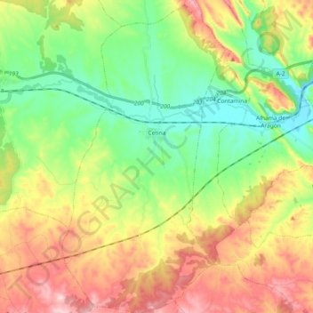
Name: Topografische Karte Cetina, Höhe, Relief.
Ort: Cetina, Comunidad de Calatayud, Zaragoza, Aragon, 50292, Spain (41.21193 -2.01731 41.34991 -1.92128)
Durchschnittliche Höhe: 786 m
Minimale Höhe: 649 m
Maximale Höhe: 991 m