
Topografische Karte Mono Craters
Interaktive Karte
Klicken Sie auf die Karte, um die Höhe anzuzeigen.
Über diese Karte
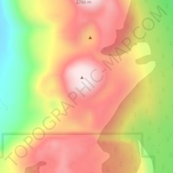
Name: Topografische Karte Mono Craters, Höhe, Relief.
Ort: Mono Craters, Mono County, California, United States (37.86238 -119.00658 37.86248 -119.00648)
Durchschnittliche Höhe: 2.541 m
Minimale Höhe: 2.218 m
Maximale Höhe: 2.779 m
Andere topografische Karten
Klicken Sie auf eine Karte, um ihre Topografie, ihre Höhe und ihr Relief anzuzeigen.
June Lake
United States > California > Mono County
June Lake, Mono County, California, 93529, United States
Durchschnittliche Höhe: 2.548 m
Mammoth Mountain
United States > California > Mono County > Mammoth Lakes
Mammoth Mountain, Mammoth Lakes, Mono County, California, United States
Durchschnittliche Höhe: 3.011 m
Owens River Headwaters Wilderness
United States > California > Mono County > Mammoth Lakes
Owens River Headwaters Wilderness, Mammoth Lakes, Mono County, CAL Fire Southern Region, California, United States
Durchschnittliche Höhe: 2.683 m
White Mountains
United States > California > Mono County
White Mountains, Mono County, California, United States
Durchschnittliche Höhe: 2.049 m
Agnew Lake
United States > California > Mono County
Agnew Lake, Mono County, California, United States
Durchschnittliche Höhe: 2.782 m
Walker
United States > California > Mono County > Walker
Walker, Mono County, California, 96107, United States
Durchschnittliche Höhe: 1.736 m
Mammoth Lakes
United States > California > Mono County
Mammoth Lakes, Mono County, California, 93546, United States
Durchschnittliche Höhe: 2.682 m
Benton Crossing
United States > California > Mono County > Benton Crossing
Benton Crossing, Mono County, California, United States
Durchschnittliche Höhe: 2.088 m