
Topografische Karte Karaka Island
Interaktive Karte
Klicken Sie auf die Karte, um die Höhe anzuzeigen.
Über diese Karte
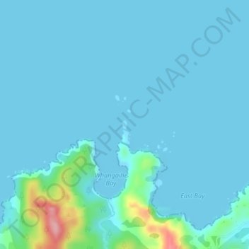
Name: Topografische Karte Karaka Island, Höhe, Relief.
Ort: Karaka Island, Northland, New Zealand (-34.99073 173.81778 -34.98972 173.81857)
Durchschnittliche Höhe: 13 m
Minimale Höhe: 0 m
Maximale Höhe: 140 m
Andere topografische Karten
Klicken Sie auf eine Karte, um ihre Topografie, ihre Höhe und ihr Relief anzuzeigen.
Reserve
New Zealand > Northland > Far North District > Bay of Islands-Whangaroa Community > Kerikeri
Reserve, Blue Marlin Estate, Kerikeri, Bay of Islands-Whangaroa Community, Far North District, Northland, New Zealand
Durchschnittliche Höhe: 56 m
Bay of Islands-Whangaroa Community
New Zealand > Northland > Far North District > Bay of Islands-Whangaroa Community
Bay of Islands-Whangaroa Community, Far North District, Northland, New Zealand
Durchschnittliche Höhe: 91 m
Russell
New Zealand > Northland > Far North District > Bay of Islands-Whangaroa Community
Russell, Bay of Islands-Whangaroa Community, Far North District, Northland, 0202, New Zealand
Durchschnittliche Höhe: 12 m
Saint Peters
New Zealand > Northland > Far North District > Bay of Islands-Whangaroa Community
Saint Peters, Bay of Islands-Whangaroa Community, Far North District, Northland, 0479, New Zealand
Durchschnittliche Höhe: 46 m
Bay of Islands
New Zealand > Northland > Far North District
Bay of Islands, Far North District, Northland, New Zealand
Durchschnittliche Höhe: 39 m